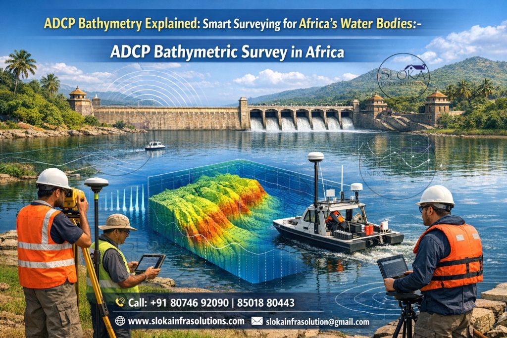
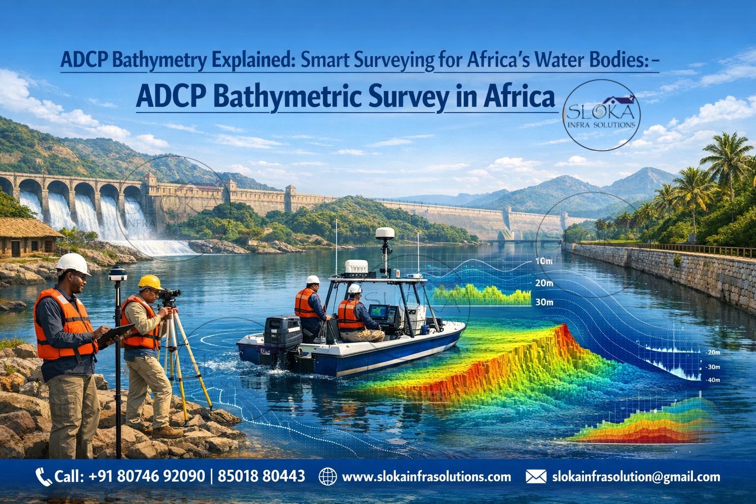
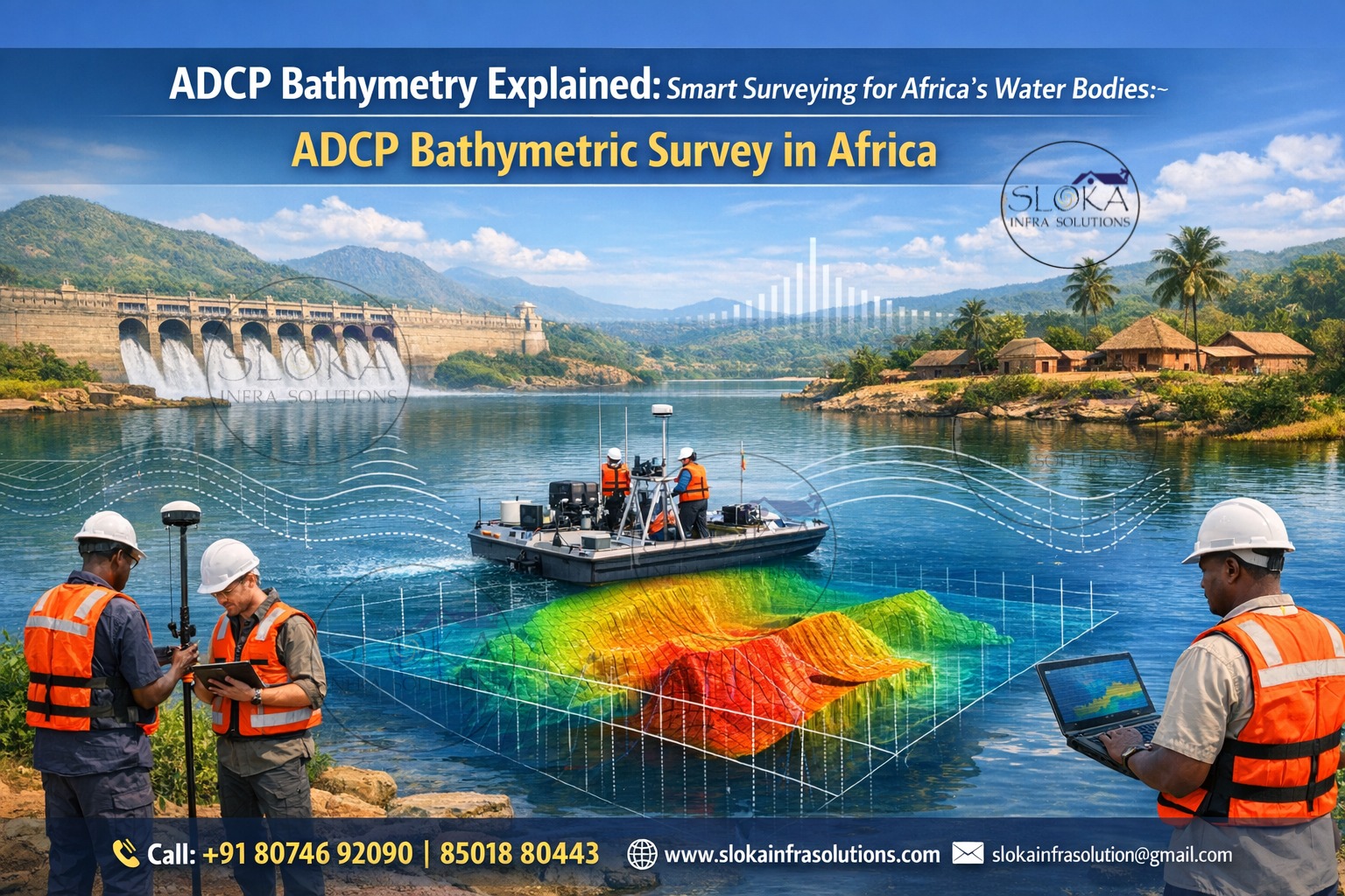
ADCP Bathymetric Survey in Africa
ADCP Bathymetry Explained: Smart Surveying for Africa’s Water Bodies:-
ADCP Bathymetric survey in Africa plays a vital role in understanding the depth, movement, and behavior of water bodies across the continent’s diverse geographic and climatic regions. From the vast African Great Lakes to fast-flowing rivers like the Nile, Congo, Niger, Zambezi, and Orange, accurate underwater mapping is essential for navigation safety, infrastructure planning, flood management, hydropower development, and environmental protection. Unlike traditional bathymetric methods that focus only on depth, ADCP-based surveys provide a powerful combination of bathymetry and water-flow intelligence, making them highly valuable for Africa’s evolving water resource challenges.
ADCP Bathymetric Surveyor in Africa
ADCP Bathymetric surveyor in Africa brings together hydrographic expertise, acoustic technology, and region-specific understanding of African water systems. Surveyors operating across Africa must work in highly varied environments—seasonal rivers, sediment-heavy deltas, deep rift lakes, reservoirs behind large dams, and dynamic coastal waters. An experienced ADCP bathymetric surveyor not only measures depths but also interprets current velocities, sediment transport, and hydrodynamic behavior to support engineering, environmental, and disaster-management decisions.
Understanding ADCP Technology in Bathymetric Surveys
An Acoustic Doppler Current Profiler (ADCP) is a sonar-based instrument designed to measure water velocity by emitting acoustic pulses and analyzing the Doppler shift of sound waves reflected from suspended particles in the water. When integrated into bathymetric surveys, ADCPs do far more than current measurement—they provide continuous depth profiles, riverbed morphology insights, and flow-depth relationships.
In African contexts, where rivers can change shape rapidly due to monsoons, cyclones, and sediment inflow, ADCP surveys allow engineers and scientists to capture real-time hydrodynamic conditions along with bathymetric data. This dual capability makes ADCPs especially effective in regions where water behavior is as critical as water depth.
Why ADCP Bathymetry is critical for Africa’s water bodies?
Africa’s geography presents unique challenges that demand advanced survey techniques. Many rivers are unregulated, seasonal, and sediment-laden, while lakes range from shallow floodplains to some of the deepest freshwater bodies on Earth.
ADCP bathymetric surveys help address these challenges by:
- Measuring depth even in high-flow conditions
- Capturing velocity profiles across the water column
- Mapping scour, erosion, and sediment deposition
- Supporting flood modeling and river engineering
- Improving safety for navigation and marine operations
This makes ADCP-based bathymetry particularly valuable in African regions experiencing climate variability, rapid urban growth, and increasing water infrastructure development.
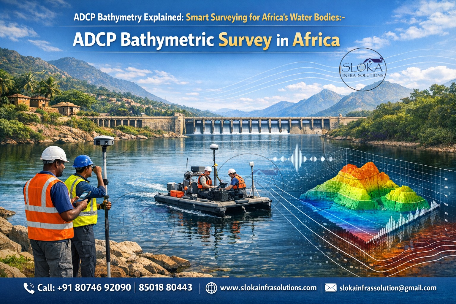
Key components of an ADCP Bathymetric Survey system
An ADCP bathymetric setup typically includes:
- An ADCP sensor mounted on a boat, floating platform, or autonomous system
- Differential GNSS for precise horizontal positioning
- Motion sensors to compensate for pitch, roll, and yaw
- Data acquisition and processing software
- Sound velocity measurement tools for calibration
In African inland waters, survey systems are often optimized for shallow depths, high turbidity, and variable flow velocities, ensuring reliable data even in challenging environments.
Survey execution in Rivers, Lakes, and Reservoirs:-
ADCP bathymetric surveys are conducted by moving the instrument across the water body along predefined transects. As the ADCP travels, it continuously records:
- Water depth
- Velocity magnitude and direction
- Riverbed shape
- Flow distribution patterns
In large African rivers, cross-sectional surveys help estimate discharge and identify erosion zones. In lakes and reservoirs, longitudinal and grid-based surveys reveal underwater slopes, submerged features, and sediment accumulation patterns.
Role of sound velocity calibration in African waters:-
Water temperature, salinity, and suspended sediment concentration affect sound speed. African water bodies often experience strong thermal stratification, especially in deep rift lakes and reservoirs.
Regular sound velocity profiling is essential to ensure depth accuracy. Calibration is typically performed multiple times during a survey day to maintain accuracy within acceptable tolerance levels, even in rapidly changing conditions.
Accuracy and reliability of ADCP Bathymetric data:-
When properly calibrated and executed, ADCP bathymetric surveys can achieve depth accuracies within a few centimeters. The added advantage lies in the simultaneous measurement of flow velocities, which allows:
- Validation of depth measurements
- Identification of unstable riverbeds
- Improved modeling of sediment transport
This reliability makes ADCP bathymetry suitable for both scientific research and large-scale engineering projects across Africa.
Applications across Africa’s Water infrastructure projects:-
ADCP bathymetric surveys are widely applied in:
- Hydropower dam planning and monitoring
- Bridge and pipeline foundation studies
- Reservoir capacity assessment
- River training and bank protection works
- Port and inland waterway development
For African nations investing heavily in water infrastructure, ADCP surveys provide a data-rich foundation for sustainable design and long-term maintenance.
Flood risk assessment and disaster Management:-
Flooding remains one of Africa’s most damaging natural hazards. ADCP bathymetric surveys play a crucial role in:
- Floodplain mapping
- River capacity analysis
- Identifying bottlenecks and constrictions
- Modeling flood wave propagation
- By combining depth
and flow data, engineers can predict how rivers respond to extreme rainfall events and design mitigation measures accordingly.
Environmental and ecological studies:-
African rivers and lakes support diverse ecosystems and millions of livelihoods. ADCP bathymetry helps environmental scientists:
- Study habitat suitability for aquatic species
- Monitor changes in river morphology
- Assess sediment movement affecting wetlands
- Evaluate impacts of dams and water withdrawals
This data is essential for balancing development with environmental conservation.
Sediment transport and scour analysis:-
High sediment loads are common in African rivers due to erosion, deforestation, and seasonal rainfall. ADCP surveys enable:
- Detection of scouring near bridge piers and dam outlets
- Measurement of sediment-driven bed changes
- Long-term monitoring of river stability
These insights help prevent structural failures and costly repairs.
Integration with other Hydrographic techniques:-
ADCP bathymetric surveys are often combined with:
- Multibeam echo sounders for high-resolution seabed mapping
- Single-beam surveys for shallow or narrow channels
- Sub-bottom profilers for sediment layer analysis
- Remote sensing and satellite data for basin-scale studies
This integrated approach enhances data quality and interpretation.
Data processing and Interpretation:-
Raw ADCP data is processed to remove noise, correct motion effects, and align depth and velocity measurements with precise coordinates. Processed outputs typically include:
- Bathymetric maps
- Velocity contour plots
- Cross-sectional flow profiles
- Time-series comparisons
These outputs support engineers, planners, and decision-makers across multiple sectors.
Remote Access and Digital Platforms in African Surveys
Modern ADCP bathymetric projects increasingly use cloud-based platforms that allow stakeholders to:
- View bathymetric and flow data remotely
- Compare changes over time
- Extract measurements and reports
- Share results without specialized software
This approach improves collaboration and data accessibility across Africa.
Challenges of ADCP Bathymetric Surveys in Africa
Despite their advantages, ADCP surveys face challenges such as:
- Logistical constraints in remote regions
- Seasonal accessibility issues
- Equipment maintenance in harsh environments
- Limited local technical capacity in some areas
Experienced survey planning and skilled operators are essential to overcome these challenges.
Training and Expertise Requirements
Effective ADCP bathymetric surveys require:
- Strong understanding of hydroacoustics
- Field experience in diverse water conditions
- Data processing and interpretation skills
- Knowledge of African hydrology and climate patterns
- Building local expertise is key to sustainable survey practices across the continent.
Future of ADCP Bathymetric Surveys in Africa
As Africa continues to invest in water infrastructure, renewable energy, and climate resilience, demand for ADCP bathymetric surveys will grow. Advances in autonomous platforms, real-time data transmission, and integrated modeling will further enhance survey efficiency and accuracy.
The continued evolution of ADCP Bathymetric survey in Africa will support smarter water management, safer infrastructure, and better protection of aquatic ecosystems.
Why ADCP bathymetry is a strong fit for many African needs?
ADCP Bathymetric survey in Africa provides a pragmatic balance of speed, cost-effectiveness and dual-purpose data (flow + depth) that matches many continent-scale priorities: irrigation and dam management, inland navigation, flood risk, and sediment budgeting. When deployed with a clear QA plan, regular SVP checks, and proper geodetic control, ADCP campaigns deliver actionable maps and volumes that influence engineering and policy decisions.
ADCP Bathymetric surveyor in Africa — whether working for a government water agency, consulting firm, or university research team — must combine fieldcraft (good offsets, regular sound-speed casts) with careful processing and uncertainty reporting. Investing a small portion of project budgets in operator training and quality control multiplies the value of every campaign: better maps, defensible numbers for dredging/storage, and more confident operational decisions.