Hydrographic Survey in Qatar
A Complete Guide to Hydrographic Survey in Qatar for Modern Marine Projects
Call: +91 80746 92090
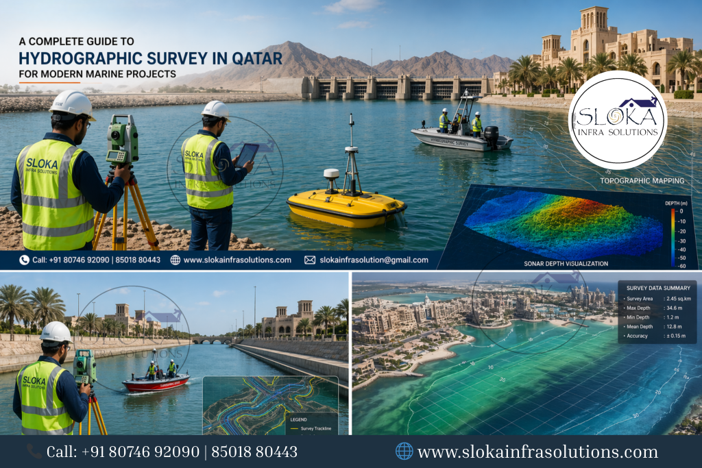
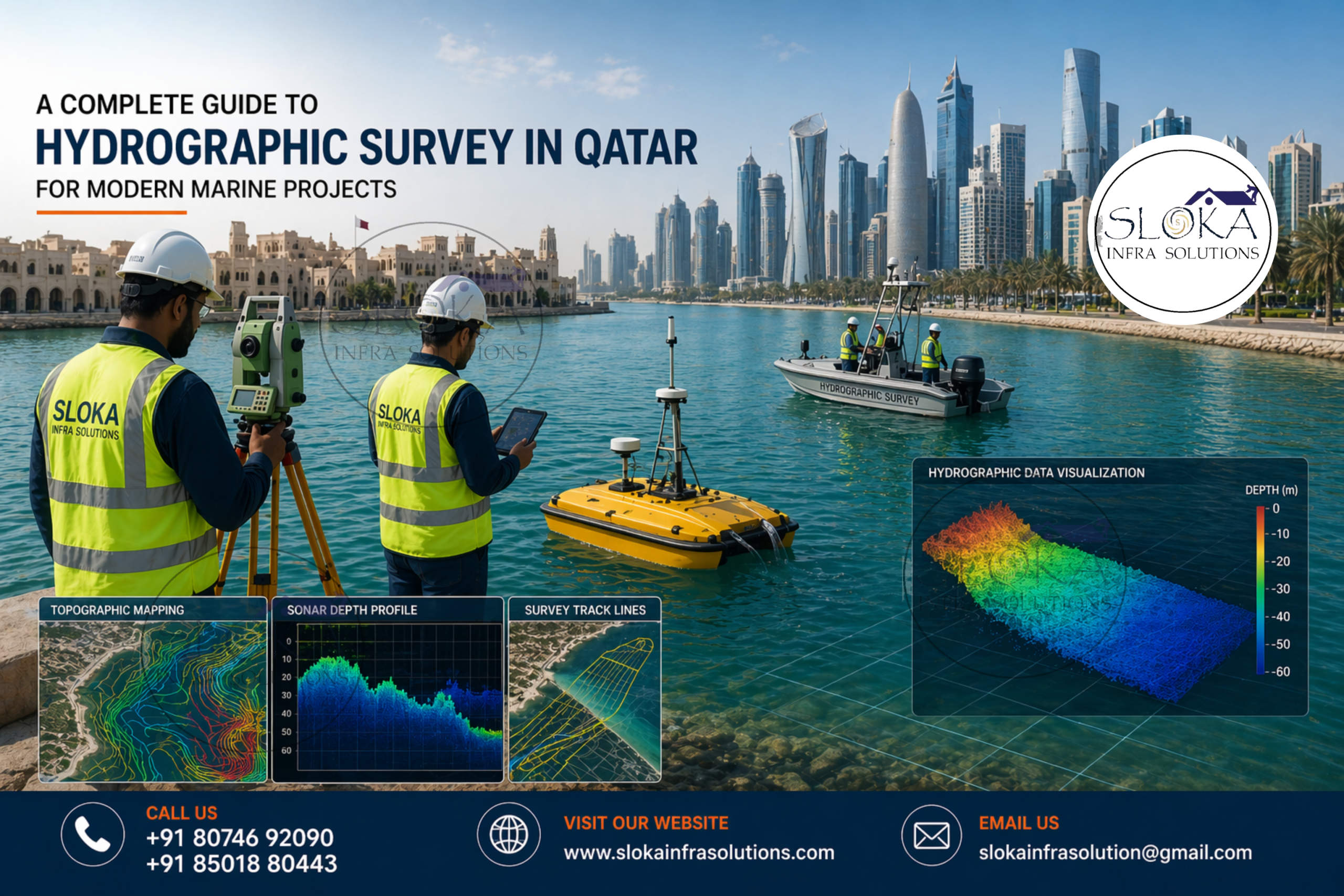
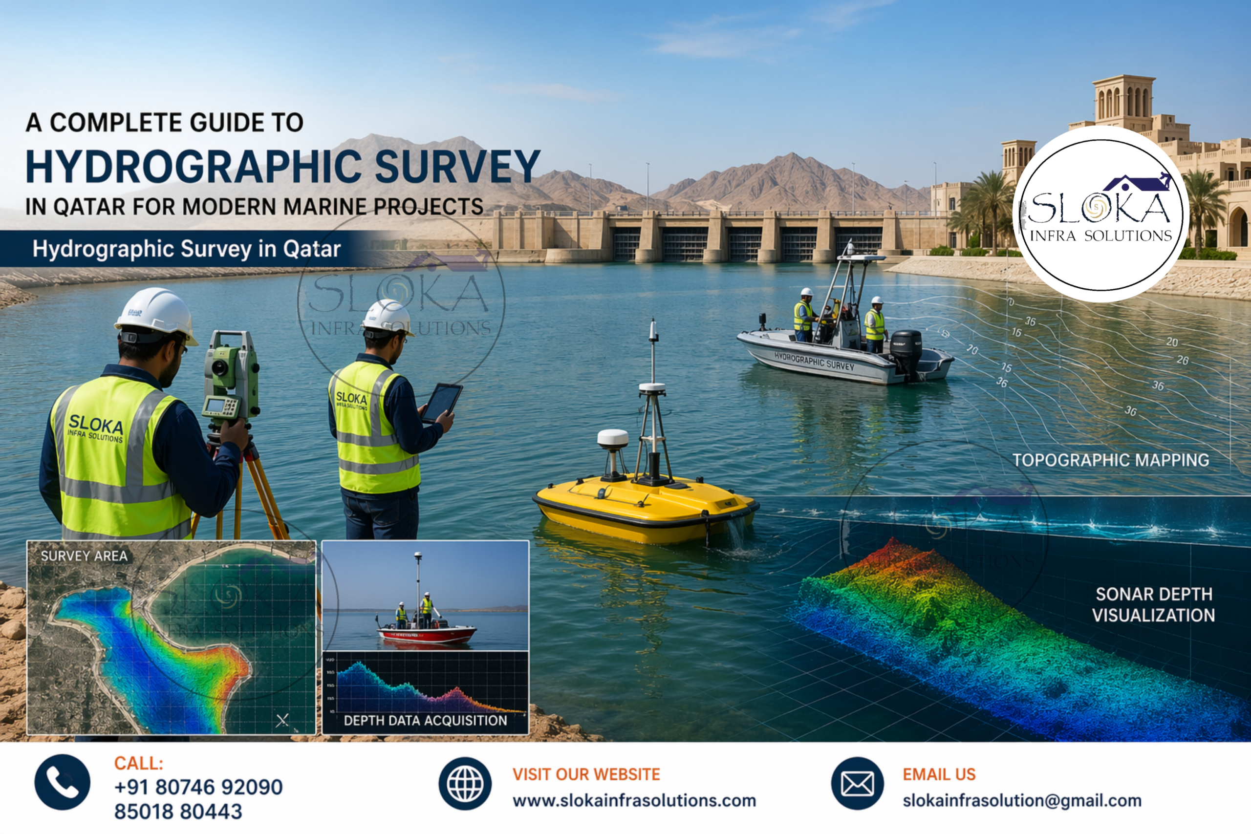
Hydrographic Survey in Qatar plays a critical role in understanding the country’s marine environment, ensuring safe navigation, supporting coastal infrastructure, and enabling sustainable offshore development. Positioned along the Arabian Gulf, Qatar is surrounded by shallow waters, dynamic seabed conditions, and rapidly expanding maritime activities. From port expansions to oil and gas exploration, accurate hydrographic data forms the backbone of decision-making across industries.
Top Hydrographic Survey & Surveyors in Qatar
Top Hydrographic Survey & Surveyors in Qatar are instrumental in supporting the country’s rapid growth in maritime trade, oil and gas operations, and coastal infrastructure. These experts use adva
nced technologies and precise methodologies to map underwater environments, ensuring accuracy, safety, and compliance with international maritime standards. Their work supports critical sectors such as dredging, offshore construction, pipeline installation, and environmental monitoring across Qatar’s coastal and offshore regions.
Understanding Hydrographic Surveying: A Foundation for Marine Intelligence:-
Hydrographic surveying is the science of measuring and describing physical features of water bodies and the adjacent coastal areas. It involves mapping seabed topography (bathymetry), identifying underwater hazards, analyzing tides and currents, and collecting data crucial for navigation, engineering, and environmental management.
In Qatar, hydrographic surveys are especially significant due to the country’s reliance on maritime trade, offshore oil and gas reserves, and coastal urban development. The shallow waters of the Arabian Gulf demand high-precision mapping to avoid risks such as vessel grounding, sedimentation issues, and infrastructure instability.
Qatar’s marine geography and why It demands precision!
Qatar’s coastline stretches over 560 kilometers, bordered by the Arabian Gulf. The marine environment is characterized by:
- Shallow depths (often less than 50 meters)
- Sandy and silty seabeds
- Coral reefs and marine habitats
- Tidal variations and sediment movement
Major water bodies and marine zones include:
- The Arabian Gulf (primary surrounding water body)
- Coastal lagoons and inlets such as Khor Al Adaid (Inland Sea)
- Artificial islands and reclaimed coastal areas
- Busy ports like Hamad Port and Ras Laffan
These factors make hydrographic surveys indispensable for maintaining safe navigation routes, supporting marine construction, and protecting ecological systems.
Core applications of Hydrographic Surveys in Qatar:-
Hydrographic surveys serve a wide range of applications, including:
1. Navigation Safety
Accurate nautical charts ensure ships can safely enter and exit ports, avoiding underwater hazards.
2. Offshore Oil & Gas Exploration
Qatar, being a global leader in LNG production, relies on hydrographic data for pipeline installation, seabed stability analysis, and platform positioning.
3. Coastal Development
With rapid urban expansion, hydrographic surveys guide land reclamation, waterfront construction, and harbor design.
4. Environmental Monitoring
Surveys help track seabed changes, marine habitats, and the impact of human activities.
5. Dredging Operations
Precise depth measurements ensure efficient dredging and sediment management.
Advanced technologies used in Hydrographic Surveys:-
Modern hydrographic surveys rely on cutting-edge tools that enhance accuracy and efficiency:
- GPS and GNSS systems for positioning
- Sonar technologies for seabed mapping
- Autonomous and remotely operated vehicles
- Data processing and visualization software
Below are detailed insights into key survey techniques used in Qatar.
1.Side Scan Sonar:
Side Scan Sonar is one of the most powerful tools used in hydrographic surveys for imaging the seabed. It operates by emitting acoustic pulses sideways from a towfish or mounted device, capturing high-resolution images of the seafloor.
In Qatar’s shallow and sediment-rich waters, Side Scan Sonar is particularly effective for identifying objects, textures, and anomalies on the seabed. It provides detailed imagery that helps detect:
- Shipwrecks and submerged debris
- Pipelines and cables
- Rock formations and coral reefs
- Seabed features like ripples and sand waves
This technology is widely used in port development, offshore construction, and environmental studies. For instance, before laying pipelines in Qatar’s offshore gas fields, Side Scan Sonar ensures the route is free from obstructions.
Another advantage is its ability to cover large areas quickly, making it ideal for reconnaissance surveys. The data collected is often combined with other survey methods to provide a comprehensive understanding of the seabed.
Despite its strengths, Side Scan Sonar does not provide depth information directly, which is why it is often used alongside echo sounders. In Qatar’s marine projects, this integration ensures both visual clarity and depth accuracy.
2.ADCP Survey (Acoustic Doppler Current Profiler):-
An ADCP Survey focuses on measuring water current velocities throughout the water column. The Acoustic Doppler Current Profiler uses sound waves to determine how fast water is moving at different depths.
In Qatar, where tidal currents and sediment transport significantly influence marine operations, ADCP surveys are vital. They provide insights into:
- Current speed and direction
- Vertical water movement
- Tidal patterns
- Sediment transport behavior
These data points are crucial for offshore construction, dredging, and environmental impact assessments. For example, when designing a marine structure like a jetty or breakwater, understanding current dynamics ensures structural stability and longevity.
ADCP instruments can be deployed from vessels, mounted on the seabed, or attached to buoys. In Qatar’s offshore zones, long-term ADCP deployments help monitor seasonal variations in currents, supporting better planning and risk management.
Additionally, ADCP data is used in numerical modeling to predict future marine conditions. This is particularly important in Qatar’s rapidly evolving coastal landscape, where human interventions can alter natural water flow patterns.
3.Sub Bottom Profilers:-
Sub Bottom Profilers are specialized equipment used to explore the layers beneath the seabed. Unlike surface mapping tools, these systems penetrate the seabed using low-frequency sound waves, revealing subsurface structures.
In Qatar, where offshore construction and pipeline installations are common, understanding subsurface conditions is critical. Sub Bottom Profilers help identify:
- Sediment layers and thickness
- Buried objects and obstacles
- Geological formations
- Potential hazards like gas pockets
This information is essential for engineering design and risk assessment. For example, before installing a subsea pipeline, engineers need to know the type and stability of the seabed layers to prevent failures.
Sub Bottom Profiling is also used in environmental studies to understand sediment deposition patterns and historical changes in the seabed.
The data is typically presented as cross-sectional images, allowing experts to interpret subsurface conditions with precision. In Qatar’s marine projects, this technology ensures safe and efficient infrastructure development.
4.Single Beam Echo Sounder Survey:-
A Single Beam Echo Sounder Survey is one of the traditional yet reliable methods for measuring water depth. It works by sending a sound pulse directly beneath the survey vessel and measuring the time it takes for the echo to return.
In Qatar’s hydrographic operations, single beam surveys are often used for:
- Preliminary assessments
- Shallow water mapping
- Channel monitoring
- Dredging verification
The simplicity and cost-effectiveness of this method make it suitable for smaller projects or areas where high-resolution data is not required.
However, since it measures depth only at a single point directly below the vessel, it provides limited coverage compared to advanced systems. Despite this limitation, it remains a valuable tool for routine surveys and quick assessments.
In Qatar’s coastal zones, where sediment movement can alter seabed levels frequently, single beam surveys help maintain updated depth information for navigation safety.
5.Multibeam Echo Sounder Survey:-
A Multibeam Echo Sounder Survey represents the most advanced form of bathymetric surveying. Unlike single beam systems, it emits multiple sound beams across a wide swath, capturing detailed depth data over a large area.
In Qatar, multibeam surveys are widely used for:
- High-resolution seabed mapping
- Port and harbor development
- Offshore engineering projects
- Pipeline and cable routing
This technology provides a 3D representation of the seabed, allowing engineers and planners to visualize underwater terrain with exceptional clarity.
Multibeam systems are particularly beneficial in Qatar’s shallow waters, where detailed mapping is essential to avoid navigation hazards and optimize marine infrastructure.
The data collected is processed using advanced software to create digital terrain models, contour maps, and visualizations. These outputs are critical for decision-making in large-scale marine projects.
Although more expensive than single beam systems, the accuracy and coverage of multibeam surveys make them indispensable for modern hydrographic applications.
Tackling complexities in Qatar’s Hydrographic surveys:-
Despite technological advancements, hydrographic surveying in Qatar faces several challenges:
- Shallow water conditions that complicate vessel operations
- High temperatures affecting equipment performance
- Sediment mobility leading to frequent seabed changes
- Marine traffic congestion in busy ports
- Environmental sensitivity requiring careful survey planning
Overcoming these challenges requires skilled professionals, robust equipment, and adaptive methodologies.
The role of Hydrographic data in sustainable development:-
Hydrographic surveys are not just about navigation—they play a vital role in sustainability. In Qatar, they support:
- Marine habitat conservation
- Coastal erosion monitoring
- Climate change impact studies
- Responsible offshore development
By providing accurate data, hydrographic surveys enable informed decisions that balance economic growth with environmental protection.
A glimpse into the future of Hydrographic Surveying in Qatar:-
The future of hydrographic surveying in Qatar is driven by innovation and digital transformation. Emerging trends include:
- Use of autonomous survey vessels
- Integration of AI and data analytics
- Real-time data processing
- Enhanced 3D visualization technologies
As Qatar continues to invest in infrastructure and offshore projects, the demand for advanced hydrographic surveys will only increase.
Bringing It all Into perspective:-
Hydrographic Survey in Qatar stands as a powerful yet often unseen force driving the nation’s maritime growth and safety. From guiding vessels through complex coastal waters to supporting large-scale offshore and infrastructure projects, it delivers the critical insights needed to understand what lies beneath the surface and make informed decisions with confidence.
In a country defined by its unique marine geography and rapid development, the role of Top Hydrographic Survey & Surveyors in Qatar becomes even more vital. Their expertise ensures accuracy, reliability, and innovation in every survey, helping balance economic progress with environmental responsibility. As technology continues to advance, hydrographic surveying will only grow more impactful, shaping smarter, safer, and more sustainable marine operations.
At its core, hydrographic surveying is not just about measuring depths—it is about unlocking opportunities, minimizing risks, and preserving Qatar’s marine environment for the future.