Bathymetric Survey in Rwanda
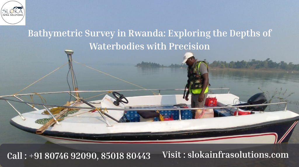
Bathymetric Survey in Rwanda: Exploring the Depths of Waterbodies with Precision:-
Call: +91 80746 92090
Bathymetric survey in Rwanda is an essential scientific and navigational process used to measure the depths and underwater topography of lakes, rivers, reservoirs, and wetlands across the nation. Rwanda, known as the “Land of a Thousand Hills,” is also blessed with numerous lakes and water systems, such as Lake Kivu, Lake Muhazi, Lake Rweru, and the Nyabarongo and Akagera river systems. Mapping these waterbodies beneath the surface is crucial for water resource management, environmental planning, infrastructure development, navigation, and ecological studies. Bathymetric surveys reveal the hidden landscape beneath the water—transforming a watery surface into detailed depth maps and valuable insights that support decision-making and sustainable development.
Bathymetric Surveyor in Rwanda
Bathymetric surveyor in Rwanda plays a pivotal role in gathering, analyzing, and interpreting underwater depth data. These professionals use state-of-the-art technologies to chart the unseen terrains beneath lakes and rivers, helping government agencies, researchers, engineers, and conservationists make informed choices. With Rwanda’s diverse waterbodies and increasing development projects around them, a skilled bathymetric surveyor becomes indispensable for ensuring safe navigation, reservoir management, flood risk assessments, and environmental protection. Their work supports everything from determining sediment accumulation patterns to guiding infrastructure projects like bridges, intakes, and hydropower installations.
Rwanda’s Water Landscape: Why Bathymetry Matters:-
Rwanda’s geography is marked by hilly terrains and numerous water systems that play a critical role in sustaining life and economic activities:
Lake Kivu – One of Africa’s Great Lakes, shared with the Democratic Republic of Congo—its depths hold secrets vital for safe navigation and methane extraction planning.
Lake Muhazi & Lake Rweru – Important local water resources influencing fisheries, tourism, and community water access.
Nyabarongo and Akagera Rivers – Principal river systems flowing through diverse landscapes, requiring detailed depth surveys for flood management and ecosystem health.
Numerous Reservoirs and Wetlands – These require continuous monitoring to manage sediment build-up, aquatic vegetation, and water storage capacities.
In a country where water is central to livelihoods, energy, food security, and biodiversity, bathymetric surveys provide critical context for sustainable management.
What is a Bathymetric Survey?
At its core, a bathymetric survey is the underwater equivalent of land topography. It measures the depth of waterbodies and maps their underwater terrain—just as topographic surveys detail the surface of the land. This process involves emitting sound waves from survey equipment into the water and measuring the time taken for echoes to return after bouncing off the bottom. These data points are then processed to form depth profiles, contour maps, and 3D models of the underwater environment. USGS
Bathymetric surveys provide:
- Depth Profiles – How deep different parts of a waterbody are.
- Underwater Terrain Maps – Including ridges, depressions, channels, and flats.
- Volume Calculations – Important for reservoir storage assessments.
- Hazard Detection – Identifying obstacles that could endanger navigation or structures.
- Environmental Insights – Including sediment dynamics and habitat mapping.
What to expect during a survey in Rwanda?
A well-run bathymetric project is more than a boat with an echo sounder. Typical steps include:
Scoping and planning: identify objectives, legal permits, local stakeholders and safety considerations.
Desk study: collect existing maps, satellite imagery and historical water-level data.
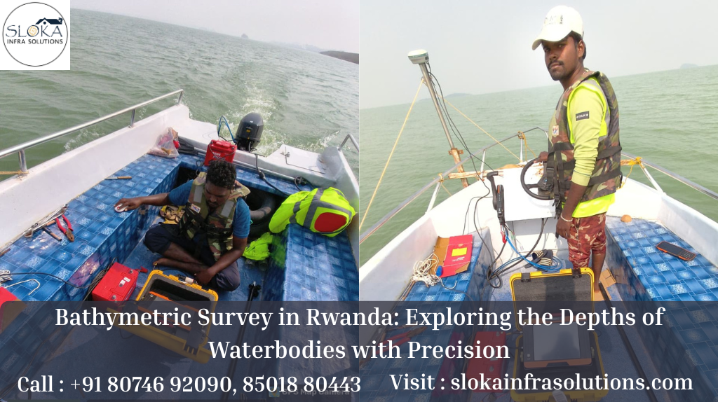
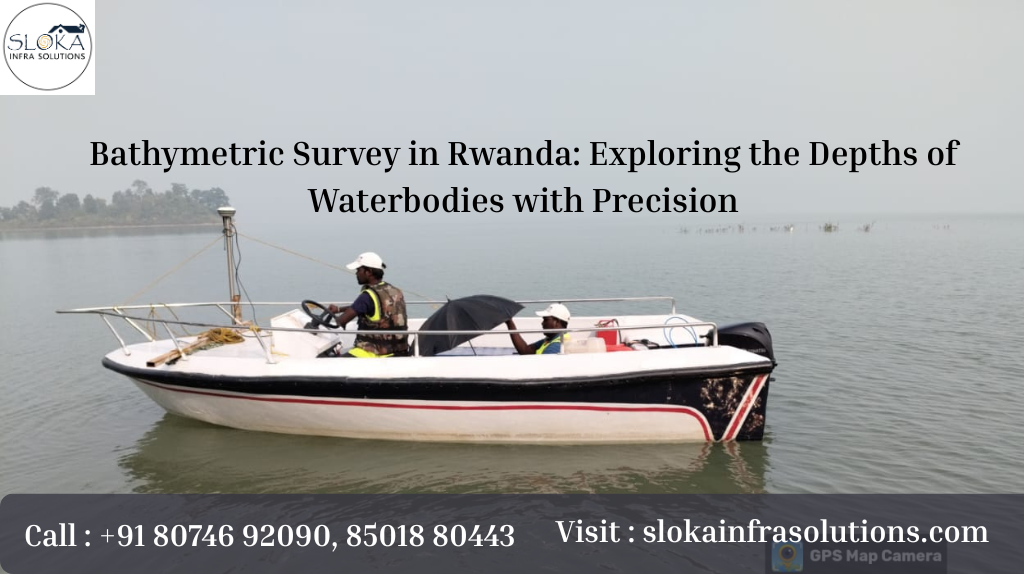
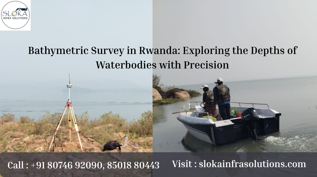
Field mobilization: bring the right vessel(s), equipment and local crew. Many surveys use small survey boats for lakes and rivers in Rwanda.
Data collection: run closely spaced survey lines across the study area, record soundings, water-level and GPS/positioning data.
Processing and QC: clean noise, correct depths for water-level variations, and build a digital elevation model and contour maps.
Delivery and interpretation: produce charts, 3D models, and a plain-language report that ties maps back to the project goals and recommendations.
Tools that matter
Most modern surveys use sonar systems to measure depth. Multibeam echosounders collect broad swaths of depth data and give very detailed terrain models. Single-beam echosounders measure depth directly beneath the vessel and are useful for constrained budgets or narrow channels. In clear, shallow water or near-shore zones, bathymetric LiDAR (airborne green-light lasers) can complement ship-based sonar and create seamless land/water elevation models. All these technologies are tools each chosen to suit the waterbody and purpose.
Key Applications of Bathymetric Surveys in Rwanda:-
Bathymetric data serve multiple sectors in Rwanda:
- Water Resource Management
Understanding underwater shape and depth helps in planning water storage, preventing excessive sediment accumulation in reservoirs and ensuring equitable distribution of water resources.
- Flood Assessment & Planning
By combining bathymetric data with river flow models, planners can predict flood zones, mitigate risk, and prepare early response strategies during heavy rains.
- Navigation and Safety
Detailed underwater maps are essential where boats, ferries, and fishing vessels operate—especially on Lake Kivu, where sudden depth changes can pose navigation hazards.
- Infrastructure Development
For bridges, water intake structures, hydropower facilities, and irrigation systems, knowing the waterbed’s features ensures structural safety and efficient design.
- Environmental Conservation
Mapping submerged habitats, sediment layers, and underwater vegetation supports biodiversity studies, fishery management, and conservation planning.
Exploring Sub Bottom Profilers: Revealing Layers Beneath the Surface
Sub Bottom Profilers (SBPs) are powerful tools used alongside traditional bathymetry equipment to look beneath the surface of the waterbed and explore what lies buried beneath. Unlike standard sonar that only maps the top of the lake or river bottom, SBPs penetrate the sediment layers—to reveal a subsurface story of geological changes, historical sediment deposition, ancient riverbeds, or buried objects. USGS+1
How SBPs Work?
Acoustic Penetration: SBPs emit low-frequency sound waves that travel through water and into the sediment.
Reflection Patterns: Different sediment layers reflect the sound back, creating distinct echoes that help outline subsurface structures.
Layer Visualization: These reflections are interpreted to visualize the stratigraphy (arrangement of sediment layers), showing thickness, composition, and distribution.
Why Sub Bottom Profilers Matter in Rwanda?
In Rwanda’s lakes and river systems:
Sedimentation Monitoring: Rwanda’s reservoirs often accumulate sediment due to soil erosion from hilly landscapes. SBPs help quantify sediment thickness and guide dredging or sediment management plans.
Ecological Studies: By understanding subsurface conditions, ecologists can study habitat suitability for aquatic organisms and the impact of sediment buildup on ecosystem health.
Infrastructure Insight: Before building intake points, dams, or docks, knowing the subsurface profile helps engineers design safer, cost-effective foundations.
SBPs provide unseen data—literally revealing what standard depth maps cannot see—giving stakeholders a fuller picture of underwater conditions.
Understanding Side Scan Sonar: Painting Acoustic Images Below the Water
While traditional bathymetry maps depths, Side Scan Sonar (SSS) paints an acoustic image of what lies across the waterbed surface. This technology uses sound waves that are sent sideways from a survey vessel or towed device. These waves reflect off textures, objects, vegetation, and sediments on the bottom—and the returns are stitched into immersive, grayscale images that resemble photographs of the underwater world. Fiveable+1
Key Capabilities of Side Scan Sonar
High-Resolution Imaging: SSS captures fine details of bottom texture, underwater features, and obstacles.
Hazard Detection: It helps locate submerged logs, boulders, debris, or lost structures that are not visible from the surface.
Habitat Mapping: Different seabed and lakebed materials reflect sound differently, helping identify zones of vegetation, soft sediment, or rocky substrates.
Application in Rwanda
In Rwanda’s diverse freshwater environments:
Navigation Safety: SSS can reveal submerged hazards that traditional depth charts might miss—especially relevant for fishing boats or transport vessels operating on lakes like Kivu.
Environmental Research: The imagery helps scientists distinguish between different bottom types—important for aquatic ecology and resource assessments.
Pre-Project Surveys: Before dredging, installing water intake systems, or constructing piers, side scan imagery helps planners visualize the seafloor and avoid surprises.
Side Scan Sonar complements traditional bathymetric data—depth measurements, sub-surface profiles, and acoustic images together form a complete underwater narrative essential for safe, efficient, and environmentally responsible operations.
Steps Involved in a Bathymetric Survey Operation:-
A professional bathymetric survey typically follows these carefully sequenced steps:
- Planning & Reconnaissance
Before any fieldwork begins, survey goals are defined. This includes deciding which waterbodies to survey, understanding their size, depth expectations, accessibility, and environmental conditions.
- Equipment Selection
Bathymetric surveys leverage technology such as:
Multibeam and single-beam echo sounders
Side Scan Sonar
Sub Bottom Profilers
GNSS/GPS for accurate positioning
Each tool is selected based on waterbody size and survey objectives. USGS
- Data Acquisition
Survey vessels systematically traverse the waterbody:
Deep waters may use multibeam systems for wide coverage.
Narrow or shallow zones may use single-beam or specialized equipment.
Side scan and SBPs collect detail and sub-surface information.
- Processing and Corrections
Raw data undergo processing to account for:
Water level variations
Vessel motion
Sound speed differences
This ensures final maps are accurate and meaningful.
- Map Creation & Interpretation
Processed data is used to generate:
Contour maps
3D terrain models
Sediment profiles
These deliverables support planners, engineers, researchers, and environmental managers in informed decision-making.
Data quality and why it matters
A bathymetric model is only as good as its inputs. Common pitfalls include poor GPS positioning, uncorrected water-level offsets, and noisy echoes from debris or thermoclines (layers in the water caused by temperature changes). Good surveyors will apply corrections, document assumptions and deliver both raw and processed data with clear metadata explaining how depths were derived. This transparency is critical when maps are used for engineering or legal purposes.
Interpreting bathymetric results — stories the maps can tell
Bathymetric maps are not static: they narrate change. By repeating surveys over time, analysts can measure sediment deposition rates, shifting channels, or the impact of erosion-control measures upstream. In Rwanda, repeat bathymetry can help show whether reforestation efforts are succeeding at reducing sediment loads into lakes and wetlands, or whether small hydropower intakes are at risk of siltation and need protective works.
Case uses that resonate in Rwanda:-
Here are concrete examples of how bathymetry supports common needs:
• Reservoir health: track sedimentation near dam intakes to plan dredging or sediment traps.
• Fisheries zoning: identify depth contours and submerged structures that fish prefer for spawning and later set sustainable harvest zones.
• Civil works: guide the placement of floating docks, intake structures, and small bridges based on stable, well-mapped bathymetry.
• Conservation planning: identify deep-water refuges for aquatic species and map wetland extents that buffer shoreline erosion.
Working with local communities — an essential ingredient
Successful surveys blend technical work with social sensitivity. Local fishers can point to shallow shoals, submerged rocks and seasonal hazards that maps alone might miss. Training local technicians in basic surveying tasks not only reduces future costs but builds local capacity for maintenance and monitoring. Community-led mapping sessions help ensure survey outputs are used — for safety, planning, and shared stewardship.
Data sharing and usability
Deliverables should be practical. Alongside raw datasets, good surveys include:
• Clear PNG/JPEG images of depth contours for quick review.
• Georeferenced digital elevation models (DEMs) for GIS use.
• A concise report in plain language explaining findings, limitations and recommended next steps.
• Simple navigation charts for small-boat operators if requested.
Why Bathymetric Surveys Are Essential for Rwanda’s Future?
In a country experiencing rapid development and a focus on sustainable water management, bathymetric surveys are more than technical exercises; they are building blocks for progress. Here’s why they matter in Rwanda:
- Better Water Security and Planning
Understanding depth profiles and sedimentation trends helps manage water availability and quality for communities and industries.
- Enhanced Safety for Navigation and Recreation
Accurate maps protect fishermen, transport services, and recreational activities on Rwanda’s lakes and rivers.
- Improved Infrastructure Outcomes
Engineering projects—from irrigation to hydropower—benefit from detailed underwater insights, reducing risk and cost overruns.
- Conservation and Biodiversity
Mapping underwater habitats supports sustainable management of aquatic ecosystems, protecting biodiversity as Rwanda balances growth with nature conservation.
Throughout this blog we’ve emphasized the role of bathymetric survey in Rwanda and the practical work of a bathymetric surveyor in Rwanda — both are essential phrases because they root technical practice in a real place and purpose. Repeat engagements, careful community consultation, and informed interpretation are what turn raw soundings into useful decisions for people, nature and the built environment.
Why underwater maps matter to everyday life! Closing thoughts: —
Underwater maps are quiet heroes: they don’t make headlines, but they quietly inform safer travel, protect local livelihoods, and help manage scarce water resources. For Rwanda — a nation that treasures its landscape and relies on its water for multiple uses — bathymetry offers a way to see beneath the surface and make choices that are both practical and future-ready. Whether you’re a planner, fisher, conservationist or curious citizen, the first step is often the same: ask the right question, bring local voices into planning, and use reliable bathymetric data to guide the path forward.