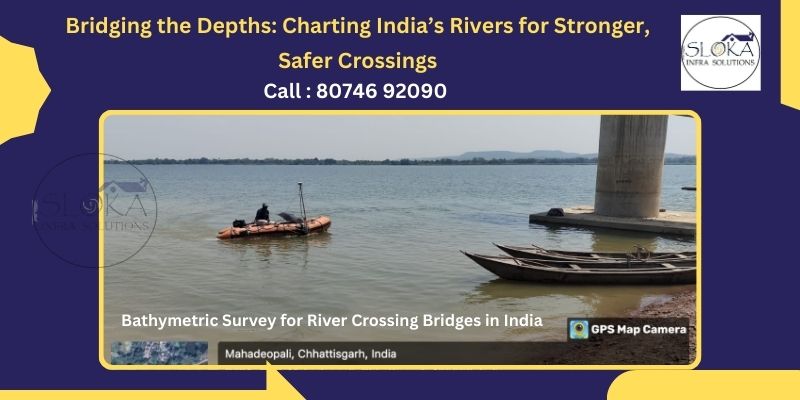
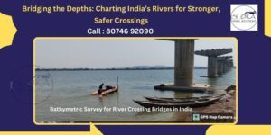
Bathymetric Survey for River Crossing Bridges in India
Bridging the Depths: Charting India’s Rivers for Stronger, Safer Crossings
Bathymetric Survey for River Crossing Bridges in India is the critical first step in understanding the hidden contours and sediment profiles of river channels where bridges will span. By generating high‑resolution depth maps and 3D models of the riverbed, engineers and planners gain the insights needed to design safe, durable foundations that can withstand variable flows, scour, and sediment transport. From the mighty Ganges to the swift Brahmaputra and the sinuous Narmada, India’s rivers present diverse challenges that make bathymetric mapping indispensable for any river crossing project.
Hydrographic Survey for River Crossing Bridges in India
Hydrographic Survey for River Crossing Bridges in India expands upon pure depth measurement to include the spatial relationship between underwater features and adjacent banks, flow velocities, and environmental parameters. This holistic approach ensures that every aspect of the river system— from channel geometry to current patterns—is accounted for in bridge design, navigation safety, and long‑term maintenance planning.
Bathymetric & Hydrographic Survey for River Crossing Bridges in India works in tandem to deliver a complete picture of river dynamics, guiding engineers toward solutions that are both structurally sound and ecologically sensitive.
1. Introduction
Bridges are vital arteries of commerce, connectivity, and community across India’s vast network of rivers. Yet, without precise knowledge of what lies beneath the water’s surface, even the most robust bridge design is at risk of unexpected scour, foundation instability, or environmental harm. Modern surveying techniques—bathymetric and hydrographic—transform our ability to map underwater landscapes and adjacent riverbanks with centimeter‑level accuracy. This blog delves into these methodologies, illustrating how they shape the future of river crossing bridge engineering in India’s unique geographical and hydrological context.
2. Significance of River Crossing Bridge Surveys in India
India’s rivers carry heavy monsoonal flows and seasonal variations that can dramatically change channel depths and bank geometries. Accurate surveying underpins:
2.1 Economic and Connectivity Imperatives
Bridges over major rivers like the Ganges, Godavari, and Cauvery unlock trade corridors and connect remote communities. Up‑to‑date bathymetric charts help maintain navigation channels for barges and ferries, reducing transport costs and enhancing regional integration.
2.2 Flood Resilience and Scour Prevention
During the monsoon, river currents accelerate, eroding bed materials around piers and abutments. Bathymetric data feeds hydraulic models that predict scour depths, enabling engineers to specify protective measures—such as riprap, mats, or deep foundations—before construction begins.
2.3 Environmental Stewardship
River ecosystems host critical habitats for aquatic fauna and flora. Hydrographic surveys capture flow velocities, sediment loads, and bank profiles, allowing planners to minimize ecological disruption and design mitigation features like fish passages or sediment bypass channels.
2.4 Optimized Urban and Rural Development
Bridges serve as vital links in transportation networks, supporting the expansion of road and rail systems that fuel economic development. Reliable survey data ensures that infrastructure is sited where banks are stable and piers rest on competent materials, reducing long‑term maintenance costs and safeguarding investments.
3. Deep Dive into Bathymetric Surveys for River Crossing Bridges
3.1 Defining Bathymetry in Bridge Context
Bathymetry for bridges involves measuring channel depths, identifying submerged obstructions, and mapping bedforms such as dunes or bars that influence flow patterns. Advanced surveys yield detailed digital elevation models (DEMs) of the riverbed, crucial for foundation design.
3.2 Survey Platforms and Sensors
- Single‑Beam and Multi‑Beam Echo Sounders: Multi‑beam systems cover wide swaths beneath a survey vessel, capturing high‑density depth points that reveal scour holes and sediment accumulation.
- Unmanned Surface Vehicles (USVs): Ideal for high‑flow or hazardous stretches, USVs equipped with echo sounders and GNSS avoid putting surveyors at risk.
- Autonomous Underwater Vehicles (AUVs): In deep pools or behind large debris, AUVs provide persistent mapping capabilities, including side‑scan sonar imagery to detect boulders or tree trunks.
- GNSS and Inertial Navigation Systems (INS): These provide precise positioning and attitude data, ensuring that each depth measurement is geo‑referenced to within centimeters.
3.3 Data Processing and Modeling
Raw sonar returns are corrected for sound‑speed variations, vessel motion, and water‑level fluctuations (tide or river stage). Sophisticated software interpolates these points into continuous 3D surfaces, enabling hydraulic simulation of flow around proposed piers and abutments.
3.4 Case Application Example: River Crossing Project on the Chambal River
A recent bridge project on the Chambal leveraged multi‑beam bathymetry to detect hidden limestone ledges and deep scour channels. By adjusting pier locations by as little as 5 m, engineers avoided high‑erosion zones, saving millions in foundation costs.
4. Exploring Hydrographic Surveys for River Crossing Bridges
4.1 Holistic Hydrography
Whereas bathymetry confines itself to depths, hydrographic surveys integrate bank profiles, vegetation cover, and current velocities. This comprehensive dataset informs design decisions on approach embankments, scour protection, and navigational clearances.
4.2 Sensor Suite and Integration
- Acoustic Doppler Current Profilers (ADCPs): Measure flow velocities at multiple depths, revealing shear stress patterns that can undercut foundations.
- Total Stations and Terrestrial LiDAR: Map bank topography and existing infrastructure (roads, utilities) to millimeter accuracy, ensuring bridge alignment fits seamlessly with the landscape.
- Unmanned Aerial Systems (UAS): Provide high‑resolution orthophotos and digital surface models (DSMs) of banks, crucial for assessing erosion risk and designing river training works.
4.3 Data Fusion and GIS
Hydrographic data layers—bathymetry, bank topography, current vectors—merge within a GIS platform to create an interactive model. Planners simulate worst‑case flood events, visualize overtopping risks, and optimize embankment slopes.
4.4 Case Application: Godavari Bridge Approaches
On the Godavari, hydrographic mapping revealed lateral channel migration over decades. By historical imagery analysis and LiDAR surveys, engineers designed flexible embankments that accommodate natural shifts, prolonging service life and reducing maintenance.
5. Comparative Insights: Bathymetric vs. Hydrographic Approaches
Although both surveys target river morphology, their scopes differ:
- Scope: Bathymetry zeroes in on underwater topography; hydrography spans both water‑column dynamics and adjacent lands.
- Data Outputs: Bathymetric surveys produce DEMs of the bed; hydrographic surveys yield complete 3D corridor models (bed to banks).
- Applications: Scour analysis and foundation sizing rely heavily on bathymetry; navigation safety, embankment design, and ecological assessments demand hydrographic insights.
By overlaying bathymetric DEMs with hydrographic corridor maps, engineers achieve a unified view that drives robust bridge design and sustainable river management.
6. Applications in River Crossing Bridge Design and Sustainability
6.1 Scour Prediction and Mitigation
Engineers use bathymetric cross‑sections and ADCP‑derived velocity profiles to model maximum scour under design flood conditions. Solutions include deep‑drilled shafts, riprap aprons, and articulated concrete mattresses.
6.2 Navigational Clearance and Channel Alignment
Hydrographic surveys ensure that bridge spans clear navigational channels even under low‑flow (draft) conditions. Precise bank and bed mapping helps align spans to minimize alteration of natural flow and sediment patterns.
6.3 Environmental and Regulatory Compliance
Survey data supports Environmental Impact Assessments (EIAs) by quantifying habitat zones, identifying spawning grounds, and ensuring that bridge piers avoid critical ecological niches.
6.4 Community Engagement and Stakeholder Trust
Visualizations generated from integrated survey data can be shared with local communities, explaining how bridge design accounts for monsoonal surges and habitat preservation—building trust and smoothing land‑acquisition processes.
7. Technological Advancements and Future Directions
Innovation continues to drive survey precision and efficiency:
- Real‑Time Kinematic (RTK) GNSS: Provides instantaneous, centimeter‑level positioning for echo sounders and UAS.
- Sensor Fusion: Combining LiDAR, sonar, and photogrammetry yields hyper‑accurate terrain models, even in turbid waters.
- Cloud‑Based Data Platforms: Enable project teams across India to access and update survey data in real time, expediting design iterations.
At the cutting edge, Sloka Infra solutions has pioneered solar‑powered USVs for sustainable, low‑emission surveys—demonstrating how eco‑friendly practices can integrate with state‑of‑the‑art technology.
8. Addressing Challenges in River Surveying
8.1 Turbidity and Signal Attenuation
Sediment‑laden monsoon waters reduce sonar penetration. Mitigation: schedule surveys immediately post‑monsoon or use higher‑frequency side‑scan sonar balanced against range limitations.
8.2 Access and Safety in Remote Locations
Hilly tributaries and dense vegetation complicate logistics. Autonomous platforms and UAS minimize human exposure, while modular equipment allows rapid deployment from makeshift launch sites.
8.3 Data Volume and Processing
High‑resolution surveys generate terabytes of data. Advanced algorithms and cloud‑based HPC clusters accelerate point‑cloud processing, enabling actionable deliverables within tight project timelines.
8.4 Regulatory and Permitting Hurdles
Surveying protected river stretches requires clearances. Early engagement with wildlife, fisheries, and water‑resource authorities, backed by precise survey plans, streamlines approvals.
9. Case Studies: Iconic River Crossing Bridges in India
9.1 New Lohpur Bridge over the Ganges
Multi‑beam bathymetry revealed deep scour scour pits near the historic confluence of the Ganges and Yamuna. Foundation piles were extended 20 m deeper than originally planned, ensuring seismic resilience.
9.2 Teesta River Cable‑Stayed Bridge
ADCP flow mapping identified peak velocities exceeding 3 m/s during spring thaws. Engineers optimized pier shapes and aligned spans to reduce vortex shedding and minimize lateral scour.
9.3 Narmada Mahadiev Bridge
Hydrographic corridor mapping captured seasonal bank undercutting. Protective revetments and realigned approach roads reduced erosion, safeguarding both the bridge and nearby farmland.
9.4 Kulsi River Arch Bridge in Assam
AUV and side‑scan sonar surveys detected submerged logs and boulders. The data guided pier placement away from debris zones, reducing construction delays and ensuring navigational safety.
10. Conclusion
The integration of bathymetric and hydrographic surveys represents a paradigm shift in river crossing bridge engineering across India. From the snow‑fed Himalayan torrents to the monsoonal deltas of the east coast, these techniques unlock a level of precision and foresight that was once unattainable. By mapping both the unseen depths and the dynamic riverbanks, engineers design bridges that stand resilient against floods, seismic events, and long‑term scour—while respecting the ecological tapestry that rivers sustain.
By revisiting the principles of Bathymetric Survey for River Crossing Bridges in India and hydrographic methodologies, stakeholders can ensure that each new span is not simply a crossing, but a harmonious link between communities, commerce, and the natural world.
11. Final Thoughts
In a nation where rivers are both lifelines and forces of nature, the marriage of cutting‑edge survey technology and thoughtful engineering cultivates bridges that endure. As India’s infrastructure aspirations soar, so too must our commitment to understanding the waterways we traverse. With every sonar ping and every aerial scan, we draw closer to a future where river crossings embody resilience, sustainability, and the promise of shared progress for generations to come.