Beneath the Surface: Revolutionizing Canal Management in Telangana with Bathymetric Insights
Bathymetric Survey for Canals in Telangana
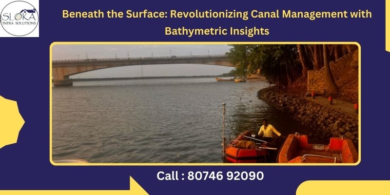
Bathymetric Survey for Canals in Telangana has emerged as a transformative force in how the state manages its complex network of water infrastructure. With a geography defined by rivers, reservoirs, and a semi-arid climate that relies heavily on engineered irrigation, Telangana’s lifeline lies in its canals—cutting across agricultural heartlands, cities, and rural landscapes. But what lies beneath the surface of these canals has often remained a mystery until now. Through advanced bathymetric techniques, this hidden world is being mapped with precision, offering a new dimension of insight that drives smarter, safer, and more sustainable water management across the state.
As Telangana intensifies its focus on water conservation, irrigation efficiency, and digital governance, bathymetric surveys—particularly for canals—are providing the critical data backbone for these initiatives. Whether it’s monitoring sedimentation, predicting flood behavior, or optimizing water flow, these underwater surveys are shaping the future of the state’s irrigation infrastructure.
Best Bathymetric Survey for Dams in Telangana
The Best Bathymetric Survey for Dams in Telangana plays a pivotal role in supporting and maintaining the network of canals connected to the state’s major reservoirs. Telangana’s dams—such as Nagarjuna Sagar, Sriram Sagar, and the colossal Kaleshwaram—feed into an intricate web of canals that deliver irrigation water to thousands of villages. Surveys of these dams not only monitor the health of the reservoir beds but also directly inform the upkeep of the downstream canal systems they support.
By integrating cutting-edge technology like multi-beam echo sounders, unmanned survey vessels, and aerial LiDAR mapping, these surveys ensure that both dam and canal infrastructure remain resilient, responsive, and ready to face modern challenges—from climate variability to rapid urban expansion.
Telangana’s Water Landscape: A Blend of Innovation and Necessity
Telangana is endowed with a wide network of rivers—particularly the Krishna and Godavari systems—and has developed a sophisticated irrigation infrastructure to harness them. However, due to uneven rainfall distribution and frequent dry spells, the state heavily depends on its man-made reservoirs and canals to supply water for agriculture, drinking, and industrial needs.
Canals like the Kakatiya Canal (originating from Sriram Sagar Dam), Devadula Canal, and the canals associated with Kaleshwaram have become indispensable. These engineered waterways must remain operational and efficient year-round, especially during critical agricultural seasons. However, over time, natural sedimentation, weed growth, and encroachment degrade the capacity and performance of these canals.
Here is where bathymetric surveys come into play—offering precise underwater terrain data that helps authorities detect problems before they become crises.
Why Bathymetric and Hydrographic Surveys Matter in Telangana
1. Boosting Agricultural Efficiency
A major portion of Telangana’s farmland, particularly in districts like Nizamabad, Karimnagar, and Warangal, is irrigated through canals. Accurate depth mapping through bathymetric surveys ensures that canals are not clogged with silt, which can otherwise prevent water from reaching tail-end users. This enhances the efficiency of water delivery and improves agricultural yields.
2. Flood Management and Disaster Prevention
Monsoons in Telangana can be both a blessing and a curse. Sudden surges in water levels can overwhelm canal systems, especially those poorly maintained or already clogged with sediment. Bathymetric data allows engineers to simulate flood scenarios and proactively plan spillways, bypass channels, and emergency gates to mitigate disaster risks.
3. Maintaining Navigability and Infrastructure Safety
Some of Telangana’s larger canals are used not just for irrigation but also for transport of materials and sometimes boats for inspection. Bathymetric surveys identify underwater obstructions, sediment accumulation, or bank collapse zones, ensuring safe navigation and structural stability for bridges and culverts.
4. Preserving Ecosystems and Biodiversity
Canals pass through various ecosystems—many of which are sensitive habitats for fish, birds, and aquatic vegetation. Unplanned dredging or strengthening of embankments can disturb the natural balance of these ecosystems. Hydrographic surveys, when coupled with bathymetric data, offer a holistic understanding that supports eco-friendly development and conservation initiatives.
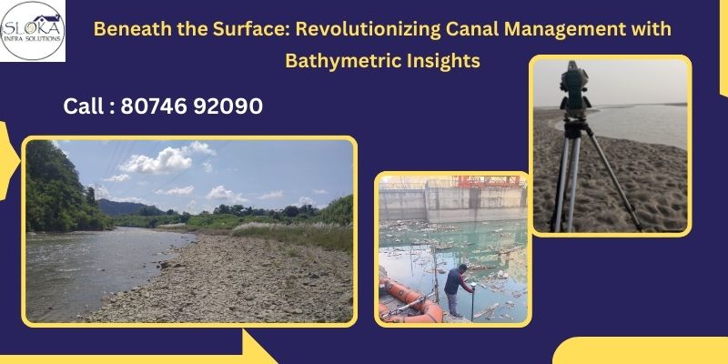
How Bathymetric Surveys Work: Technologies and Methodologies
A. Single-Beam and Multi-Beam Echo Sounders
Single-beam systems are cost-effective and suitable for narrow canals in rural Telangana. However, for broader, more critical canals like the Kakatiya or Mid Manair, multi-beam systems provide dense datasets and full coverage of the canal bed in high resolution.
B. Side-Scan Sonar and LiDAR
Side-scan sonar gives a photographic-like image of the canal floor, highlighting submerged vegetation, construction debris, or rock outcrops. Airborne LiDAR bathymetry is useful in clear water bodies and can be used to map both the water body and surrounding terrain.
C. Unmanned Surface Vehicles (USVs)
USVs are increasingly deployed in Telangana’s hazardous or inaccessible canal stretches. They can be remotely operated to gather depth, velocity, and imagery data without risking human safety.
D. Data Processing Tools
Software like HYPACK, QINSy, and ArcGIS are used to convert raw acoustic signals into useful depth maps, 3D models, and contour charts. These outputs are integrated into digital twin systems or GIS dashboards used by irrigation departments.
What is a Hydrographic Survey and Why It Complements Bathymetry
While bathymetric surveys focus primarily on underwater topography, hydrographic surveys include the broader aquatic environment—covering bank profiles, flow dynamics, water quality, and adjacent infrastructure.
Key Components of Hydrographic Surveys:
- ADCPs (Acoustic Doppler Current Profilers): Measure flow velocity at different depths.
- UAV Aerial Mapping: Used to detect illegal encroachments, vegetation overgrowth, and infrastructure damage.
- Water Quality Probes: Monitor parameters like pH, turbidity, dissolved oxygen, and contaminants.
- Bank Erosion Mapping: Helps identify unstable slopes and potential breach zones.
Applications in Telangana’s Canal Network
1. Kaleshwaram Lift Irrigation Scheme (KLIS)
This mega-project involves multiple canals and reservoirs. Regular bathymetric surveys are used to monitor the health of surge pools, pump houses, and distribution canals. These insights ensure energy-efficient pumping and reduced maintenance costs.
2. Restoration of Sriram Sagar Project (SRSP)
With the help of hydrographic surveys, engineers were able to design embankment reinforcements and sluice gate modifications that have improved flood resilience and prolonged the life of the SRSP canal systems.
3. Mission Kakatiya
As part of this mission to rejuvenate tanks and canals, bathymetric surveys help assess silt volumes and guide desilting efforts, especially in northern districts where sedimentation is high due to topography and soil types.
Technological Advancements on the Horizon
1. AI-Powered Predictive Analytics
By feeding historical bathymetric data into AI models, engineers can predict future sediment build-up or bank erosion hotspots, allowing timely preventive actions.
2. Edge Computing and IoT
Real-time processing of sensor data using edge devices ensures that critical alerts—like water level spikes or turbidity changes—are instantly relayed to authorities.
3. Immersive Digital Twins
Creating a real-time, interactive 3D simulation of Telangana’s major canals will revolutionize decision-making, especially for planning repairs, expansions, or flood responses.
4. Community-Based Monitoring
Citizen scientists and local farmers can now participate in water monitoring through mobile apps and low-cost sensors, complementing official bathymetric and hydrographic data.
Strategic Benefits to Telangana
- Efficient Irrigation: Better canal depth data ensures timely water delivery to farms, especially in tail-end areas often neglected due to poor canal health.
- Water Conservation: Precise data helps reduce wastage and over-irrigation.
- Urban Planning: In cities like Hyderabad, understanding the canal system supports smart drainage and waste management planning.
- Resilience to Climate Change: Dynamic canal modeling allows adaptive responses to changing rainfall patterns and extreme weather.
Conclusion
Bathymetric Survey for Canals in Telangana serves as a vital foundation for advancing the state’s water management strategies, enabling data-driven decisions and sustainable irrigation practices. In a land where every drop of water counts, knowing what lies beneath our canals makes all the difference between reactive maintenance and proactive planning. From silt-laden distributaries to wide concrete canals feeding lifelines like KLIS, bathymetric surveys are unveiling the stories buried underwater.
Coupled with Best Bathymetric Survey for Dams in Telangana, these techniques ensure a unified, data-driven approach to managing both reservoirs and their connected canals. The ability to map, analyze, and act on canal data in real-time ensures Telangana’s irrigation and urban water systems are not just operational—but optimized for sustainability, safety, and service.
The way forward for Telangana is clear: embrace technology, invest in data, and continue exploring the depths—both literally and strategically—to build a water-secure future for generations to come.