Bhutan’s Hydrographic Revolution: Top Surveyors Mapping the Future of Sustainable Water Management
Hydrographic Survey in Bhutan is a pivotal practice that intertwines state-of-the-art technology with an in-depth understanding of aquatic landscapes to support sustainable water management initiatives. As nations worldwide seek to harness the potential of their water resources, Bhutan stands out with its commitment to preserving the natural beauty and vitality of its water bodies. In this ever-evolving domain, the role of hydrographic surveys transcends basic measurement; it becomes a cornerstone of strategic planning, environmental conservation, and infrastructural development. The country’s myriad rivers, lakes, and reservoirs are not just scenic assets but essential resources that demand meticulous mapping and analysis.
Hydrographic surveying is more than a scientific endeavor; it is a holistic approach that integrates modern instrumentation, geospatial analysis, and traditional field expertise to create detailed representations of underwater terrains. This discipline plays a crucial role in identifying navigational hazards, planning flood control measures, and supporting economic activities ranging from transportation to tourism. Moreover, the insights derived from these surveys contribute significantly to disaster preparedness and resource allocation, ensuring that communities remain resilient in the face of natural challenges. As Bhutan continues to experience rapid urbanization and climatic shifts, investing in accurate hydrographic data becomes indispensable for crafting policies that safeguard both the environment and public welfare. By leveraging advanced tools and innovative methods, surveyors are able to capture intricate details of underwater features hidden from view. Their work lays the foundation for safe navigation and efficient water resource management, ensuring that both local communities and national infrastructure can thrive in harmony with nature. As we delve deeper into this subject, the transformative impact of these surveys on Bhutan’s sustainable development becomes evident.
Top Hydrographic Survey & Surveyors in Bhutan
Top Hydrographic Survey & Surveyors in Bhutan are known for their exceptional ability to blend traditional techniques with modern innovations, offering unparalleled accuracy in underwater mapping. These professionals employ a diverse array of methods to assess the hidden dimensions of water bodies, combining acoustic technologies with high-resolution imaging to create detailed representations of the underwater world. Their work is crucial not only for navigation and construction but also for environmental monitoring and resource management. With the help of advanced tools and meticulous planning, surveyors can detect subtle changes in underwater landscapes that may indicate shifts in sedimentation, water quality, or ecological balance.
In recent years, the methodology of hydrographic surveying has undergone significant advancements. Modern surveyors utilize sonar systems, both single-beam and multi-beam, to measure water depths accurately. These systems emit sound waves that reflect off the seabed, providing critical data that forms the basis of nautical charts and flood risk maps. Additionally, technologies such as LiDAR and unmanned survey vessels (USVs) have revolutionized the field by offering the ability to conduct surveys in challenging conditions and remote locations. The integration of Geographic Information Systems (GIS) further enhances the capability to analyze and visualize the collected data in three-dimensional formats, enabling a comprehensive understanding of underwater terrains.
The evolution of these techniques has also spurred improvements in safety protocols and data accuracy. Survey teams now operate with greater efficiency, equipped with real-time monitoring systems that ensure the reliability of the information gathered. The ability to rapidly process and interpret large volumes of data has empowered decision-makers to implement water management strategies that are both proactive and sustainable. As a result, communities benefit from improved infrastructure planning, enhanced disaster preparedness, and better environmental stewardship.
Moreover, the meticulous work carried out by hydrographic surveyors contributes significantly to the development of smart cities and sustainable urban planning initiatives. The detailed maps and models produced serve as indispensable tools for engineers and policymakers, guiding them in making informed decisions that support long-term growth and resilience. The dedication and expertise of these professionals underscore the importance of integrating scientific precision with practical applications, ultimately contributing to a safer and more prosperous future for all. Their efforts in refining surveying techniques have not only enhanced data reliability but also fostered a culture of innovation within the hydrographic community. This ongoing commitment to excellence ensures that every survey contributes to a deeper understanding of Bhutan’s water environments.
Understanding Hydrographic Surveying
Hydrographic surveying is a specialized field focused on measuring and mapping the physical features of bodies of water. This process involves collecting data on water depths, underwater terrain, and obstacles that may affect navigation or infrastructure development. In Bhutan, where water bodies are central to both the economy and cultural identity, hydrographic surveying is an essential practice that supports everything from transportation safety to flood management.
At its core, hydrographic surveying combines field measurements with advanced technological tools. Traditional methods, such as lead-line soundings, have given way to sophisticated sonar systems that provide high‑resolution, real‑time data. These modern instruments use sound waves to detect underwater features, generating detailed profiles of the seabed or riverbed. The data collected is then integrated into Geographic Information Systems (GIS) for analysis and visualization, allowing surveyors to create comprehensive maps and models.
In addition to depth measurements, hydrographic surveys capture important information about underwater sediment composition and potential hazards like submerged rocks or wrecks. This multi‑dimensional view is critical for ensuring the safety of navigation, whether it’s for commercial shipping, recreational boating, or the maintenance of infrastructure such as bridges and dams.
Furthermore, the practice is evolving to meet emerging challenges. With the impacts of climate change becoming more pronounced, real‑time monitoring of water levels and sediment shifts is increasingly important. Hydrographic surveying provides the necessary data to forecast flood events, design resilient structures, and adapt water resource management strategies to changing environmental conditions.
Overall, understanding hydrographic surveying means appreciating its role in protecting communities, supporting economic growth, and preserving natural resources. It is a field where precision, technology, and environmental sensitivity converge to create a clearer picture of our underwater world.
Technological Innovations in Hydrographic Surveying
In recent years, technological breakthroughs have revolutionized hydrographic surveying in Bhutan. The advent of advanced sonar systems, unmanned survey vessels (USVs), and remote sensing technologies has transformed the way underwater data is collected, processed, and interpreted. These innovations have not only increased the accuracy of surveys but also enhanced efficiency and safety in challenging aquatic environments.
Modern sonar systems, including both single-beam and multibeam variants, have replaced older methods of measuring water depth. These systems emit sound waves that bounce off underwater surfaces, providing precise measurements of depths and detailed images of the seafloor. The resulting data can be used to generate high‑resolution, three-dimensional maps, which are crucial for navigation, infrastructure planning, and environmental monitoring.
Unmanned survey vessels have further pushed the envelope by enabling surveys in conditions that may be too dangerous or inaccessible for manned operations. These autonomous platforms are equipped with a suite of sensors and data recording devices, allowing them to operate continuously over long periods and across vast areas. Their use significantly reduces human risk and operational costs while improving data consistency and coverage.
Remote sensing technologies, such as LiDAR and satellite imagery, offer complementary perspectives to traditional sonar methods. LiDAR, for instance, uses laser pulses to capture detailed topographical data, particularly useful in shallow water and coastal zones. When integrated with sonar data, LiDAR helps create comprehensive models of underwater terrains and aids in identifying subtle features that might otherwise be overlooked.
The integration of these technological advancements into a cohesive workflow has been further facilitated by sophisticated software tools. Geographic Information Systems (GIS) allow surveyors to overlay, analyze, and visualize data from various sources. This integrated approach not only enhances the accuracy of maps but also provides insights into environmental trends and potential hazards.
Overall, the technological innovations in hydrographic surveying are driving a paradigm shift in water resource management. By combining high‑resolution data, automation, and advanced analytics, Bhutan’s surveyors are better equipped to address the challenges of modern water management and to ensure that their nation’s precious aquatic resources are preserved for future generations.
Side Scan Sonar: Illuminating the Hidden Underwater World
Side scan sonar is a game‑changing technology in the field of hydrographic surveying. This innovative system uses sound waves emitted from transducers mounted on either side of a survey vessel. As these waves travel underwater, they create detailed acoustic images of the seafloor, revealing features that are otherwise hidden from conventional observation methods.
The power of side scan sonar lies in its ability to cover large areas quickly and efficiently. Unlike traditional depth‑measuring techniques, which focus solely on the vertical profile of the underwater landscape, side scan sonar provides a wide‑angled view. This panoramic perspective is especially useful for identifying objects, debris, or potential hazards scattered across the seabed. Surveyors can detect shipwrecks, submerged rocks, and even variations in sediment type with remarkable clarity.
Another significant advantage of side scan sonar is its versatility. It is applicable in various aquatic environments, ranging from deep open waters to shallow coastal regions. This flexibility makes it an invaluable tool in environmental assessments, underwater archaeology, and even in the detection of unexploded ordnance. By delivering high‑resolution images, the technology assists in precise mapping, which is critical for both commercial and research purposes.
The operation of side scan sonar is both robust and efficient. During a survey, the system emits pulses of sound that reflect off the seafloor and return to the sensor. These echoes are then processed to create detailed imagery. The resulting data not only provides insights into the physical layout of the seabed but also helps in identifying changes over time. Continuous monitoring using side scan sonar can reveal sediment shifts, erosion patterns, and other dynamic processes that are key to understanding underwater environments.
Furthermore, the integration of side scan sonar with modern data processing software has significantly enhanced its utility. Real‑time image processing and advanced visualization techniques allow surveyors to interpret data on‑the‑fly. This rapid turnaround is crucial for time‑sensitive projects such as disaster response and emergency navigational planning.
In summary, side scan sonar has emerged as an essential component in modern hydrographic surveying. Its ability to produce detailed, high‑resolution images across expansive areas has not only improved the accuracy of underwater maps but also opened new avenues for research and exploration. As technological advancements continue, side scan sonar remains at the forefront of innovations that are illuminating the hidden underwater world.
Sub Bottom Profiling: Revealing the Earth’s Underwater Secrets
Sub bottom profiling is a specialized technique that delves into the layers beneath the seabed or riverbed, offering an unparalleled glimpse into the geological history hidden beneath the water’s surface. This method employs advanced acoustic systems that transmit low‑frequency sound pulses into the substrate. As these pulses penetrate the layers of sediment and rock, they reflect back to the receiver, enabling surveyors to map the stratigraphy and composition of the sub‑surface.
One of the key benefits of sub bottom profiling is its ability to identify buried objects and structural features. From ancient shipwrecks to natural sediment layers, the technology unveils details that are often invisible to surface mapping techniques. This capability is crucial not only for navigation safety but also for archaeological research and environmental studies. Understanding the sedimentary structure helps in assessing the stability of the seabed and in predicting potential geohazards.
In the context of hydrographic surveying, sub bottom profiling provides a multi‑dimensional view of the underwater environment. By analyzing the different acoustic responses from various layers, surveyors can determine the composition, thickness, and even the age of sediment deposits. This information is vital for designing underwater structures, planning dredging operations, and managing coastal erosion. Moreover, it aids in groundwater exploration by revealing aquifer boundaries and sediment porosity.
Modern sub bottom profilers are equipped with state‑of‑the‑art data processing software that converts raw acoustic signals into clear, interpretable images. These systems often work in tandem with other survey technologies, such as multibeam and side scan sonar, to provide a comprehensive picture of the underwater terrain. The synergy between these tools enhances the overall reliability of the survey data and allows for more informed decision‑making in both commercial and environmental projects.
Additionally, the continuous improvement in acoustic sensor technology has significantly increased the resolution and depth of sub bottom profiles. This means that even subtle changes in the sub‑surface layers can be detected and analyzed, offering insights into historical geological events such as sediment deposition, tectonic shifts, and erosional processes. Such detailed profiling not only aids in resource exploration but also supports environmental conservation efforts by tracking changes in underwater habitats.
Overall, sub bottom profiling is a vital technique that enriches our understanding of what lies beneath the water’s surface. Its ability to reveal the hidden layers of the seabed makes it indispensable for a range of applications, from infrastructure development to environmental management. As technology continues to advance, the precision and utility of sub bottom profiling will only grow, unlocking further secrets of the Earth’s underwater world.
Single Beam Survey: A Fundamental Approach to Depth Measurement
Single beam survey is one of the most traditional yet reliable methods of hydrographic surveying. In this technique, a single sonar transducer mounted on the survey vessel emits sound pulses directly downward. The time taken for the sound waves to travel to the seabed and back is measured, allowing surveyors to calculate the depth at a specific point with precision.
Despite the advent of more sophisticated methods, single beam surveys remain widely used due to their simplicity and cost‑effectiveness. The technology is straightforward: a pulse of sound is emitted, it reflects off the seabed, and the returning echo is recorded. The depth is then determined by applying the speed of sound in water to the travel time. This method provides highly accurate point‑based measurements, which are crucial for establishing baseline depth data and calibrating more advanced systems.
One of the major advantages of single beam surveying is its adaptability to various water conditions. Whether in deep open waters or in shallow coastal areas, single beam systems deliver reliable measurements. They are particularly valuable in regions where complex underwater features are minimal, allowing for quick and efficient data collection. Additionally, single beam surveys are less susceptible to some of the interference issues that can affect multibeam systems, making them a dependable choice for preliminary surveys and routine monitoring.
The simplicity of the single beam system also contributes to its longevity as a preferred method in many applications. It requires relatively minimal maintenance and can be deployed on smaller, more agile vessels. This flexibility is important for rapid assessments, especially in environments where weather or accessibility may be challenging. Furthermore, the data obtained through single beam surveys serve as a vital reference point for more detailed studies and for validating data from more complex systems like multibeam sonars.
Modern iterations of single beam technology have improved resolution and accuracy without compromising on the core principles of the method. Innovations in sensor design and data processing have refined the ability to capture subtle depth variations, ensuring that even small features on the seabed are recorded. These improvements have made single beam surveys indispensable in a variety of sectors, including coastal engineering, environmental monitoring, and navigational charting.
In summary, while newer technologies have expanded the toolkit available for hydrographic surveying, the single beam survey remains a fundamental and effective method for depth measurement. Its reliability, simplicity, and adaptability ensure that it continues to be a cornerstone of underwater mapping, supporting both traditional survey needs and modern hydrographic research.
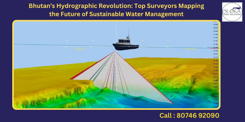
Multibeam Survey: Advanced Mapping for Detailed Seafloor Topography
Multibeam surveying represents a leap forward in hydrographic mapping, offering a comprehensive and high‑resolution view of the seafloor. In contrast to single beam systems, multibeam sonar emits multiple sound beams simultaneously across a wide swath beneath the vessel. This method generates a dense array of depth measurements, which are then compiled into detailed three‑dimensional models of the underwater terrain.
The strength of multibeam surveys lies in their ability to capture an expansive area in a single pass. The technology’s wide coverage not only speeds up the surveying process but also ensures that every detail—from subtle undulations to significant geological formations—is documented. The resulting bathymetric maps provide surveyors, engineers, and planners with a nuanced understanding of underwater features, which is critical for safe navigation, infrastructure planning, and environmental assessments.
Multibeam sonar systems incorporate advanced signal processing algorithms that correct for variations in water temperature, salinity, and vessel motion. These corrections are essential for achieving high accuracy, as even minor discrepancies can lead to significant errors in depth readings. The processed data yield high‑resolution imagery that is used to identify underwater hazards, sediment distribution, and even biological habitats. Such detailed information is invaluable for applications ranging from the construction of underwater pipelines to the management of marine protected areas.
In addition to its technical prowess, multibeam surveying also exemplifies efficiency and cost‑effectiveness. By covering large areas quickly and reducing the need for multiple survey passes, this technology optimizes both time and resources. The comprehensive data sets obtained from multibeam systems are integral to updating nautical charts and for conducting periodic assessments of seabed changes caused by natural or human activities.
Furthermore, the integration of multibeam survey data with Geographic Information Systems (GIS) has revolutionized underwater mapping. GIS platforms enable the overlay of multibeam data with other spatial information, facilitating a more holistic analysis of aquatic environments. This integration supports a wide range of applications, from coastal zone management to emergency response planning, by providing a detailed digital terrain model that can be manipulated and analyzed in real time.
Overall, multibeam surveying stands at the cutting edge of hydrographic technology. Its ability to deliver high‑resolution, wide‑coverage data has transformed underwater mapping, making it an indispensable tool in modern water resource management. As advancements continue, multibeam systems are poised to further enhance our understanding of the complex dynamics shaping the seafloor.
Case Studies and Real-World Applications
Across Bhutan and beyond, real-world applications of hydrographic surveying illustrate its profound impact on water resource management and environmental preservation. In many coastal and riverine communities, detailed underwater maps have become the backbone of infrastructural development and disaster mitigation strategies. Case studies from diverse projects reveal how accurate, up‑to‑date survey data translate into safer navigation routes, improved urban planning, and more resilient flood control systems.
For example, in a recent survey project along one of Bhutan’s major rivers, surveyors combined single beam, multibeam, and side scan sonar technologies to develop a comprehensive digital model of the riverbed. This integrated approach not only identified previously undocumented underwater hazards but also helped engineers design more effective flood mitigation measures. The data proved invaluable during periods of heavy rainfall, where precise knowledge of the river’s behavior enabled timely interventions that minimized property damage and safeguarded local communities.
In another case, a coastal hydrographic survey in a neighboring region employed sub bottom profiling to assess sediment stability and detect potential landslide risks beneath the seabed. The detailed stratigraphic images provided critical insights into sediment composition and layering, which informed both environmental conservation efforts and coastal development plans. Such projects highlight the technology’s role in bridging the gap between natural processes and human interventions.
Furthermore, the integration of survey data into Geographic Information Systems has facilitated collaborative efforts between government agencies, research institutions, and private enterprises. By sharing high‑resolution maps and dynamic models, stakeholders are better positioned to address environmental challenges, manage natural resources, and plan sustainable infrastructure projects. These collaborative platforms ensure that the benefits of advanced hydrographic surveying extend to a broad range of sectors, including transportation, energy, and tourism.
Case studies also underscore the importance of continuous monitoring. In regions prone to seismic activity or rapid sediment shifts, regular hydrographic surveys provide a critical early warning system. By tracking changes in underwater topography over time, surveyors can detect potential hazards before they escalate, ensuring that communities have the information they need to respond effectively to natural disasters.
Ultimately, these real‑world examples confirm that hydrographic surveying is more than a technical exercise—it is a vital tool for enhancing public safety, optimizing resource management, and promoting sustainable development. As technological innovations continue to drive the field forward, the lessons learned from these projects will help shape the future of underwater exploration and environmental stewardship.
Challenges in Hydrographic Surveying
Despite the remarkable advancements in hydrographic surveying technology, numerous challenges remain. Field operations often contend with unpredictable weather conditions, rugged underwater terrains, and complex sediment compositions that can hinder data accuracy. In Bhutan, where the interplay of natural beauty and geographical complexity is pronounced, these challenges are particularly significant.
One of the primary difficulties in hydrographic surveying is dealing with rapidly changing water conditions. Variations in water temperature, salinity, and turbidity can affect the speed of sound, leading to potential errors in sonar measurements. Survey teams must continuously calibrate their equipment and adjust for environmental variables to maintain data accuracy. Additionally, seasonal changes such as monsoon rains or melting snow can alter water levels and sediment distribution, requiring frequent updates to hydrographic maps.
Accessing remote or hazardous areas also poses logistical challenges. Many survey sites in Bhutan are located in regions that are difficult to reach due to steep terrains, narrow river channels, or politically sensitive zones. Deploying advanced survey vessels and ensuring the safety of personnel under such conditions often necessitates meticulous planning and significant resource investment. Moreover, the cost of high‑end equipment like multibeam sonar systems and unmanned survey vessels can be prohibitive, especially for smaller projects or organizations with limited budgets.
Data integration presents another formidable obstacle. Modern surveys generate vast quantities of data from multiple sources—sonar, LiDAR, sub bottom profilers, and satellite imagery. Merging these disparate data sets into a coherent, high‑resolution model requires sophisticated software and expert analysis. Errors or inconsistencies in one data set can compromise the overall accuracy of the model, demanding rigorous quality control protocols and continuous training for survey teams.
Despite these challenges, ongoing technological innovations and collaborative efforts are gradually overcoming many of the hurdles in hydrographic surveying. Improved sensor accuracy, automated data processing, and enhanced vessel capabilities are making it possible to achieve greater precision in even the most demanding environments. However, the path forward will require continued investment in research, technology, and human capital to ensure that the full potential of hydrographic surveying is realized.
Ultimately, while challenges persist, the commitment to excellence in the field drives surveyors to innovate and adapt. Their resilience in the face of adversity ensures that hydrographic surveying continues to evolve, delivering the critical data needed to manage water resources and protect communities in an ever‑changing environment.
Best Practices and Industry Leaders
The advancement of hydrographic surveying is fueled not only by technological innovation but also by adherence to best practices and the leadership of pioneering organizations. In Bhutan and across the globe, industry leaders are setting high standards for accuracy, safety, and environmental stewardship in underwater mapping.
A cornerstone of best practice in hydrographic surveying is rigorous equipment calibration and regular maintenance. Ensuring that sonar systems, GPS devices, and other sensors are operating within specified tolerances is essential for collecting reliable data. Many survey teams follow international standards—such as those outlined by the International Hydrographic Organization—to ensure consistency and interoperability across projects. Adopting these standards also facilitates collaboration between different agencies and experts, helping to create comprehensive and reliable data sets.
In addition to technical protocols, effective project management is critical. Successful survey projects are characterized by meticulous planning, clear communication, and the ability to adapt to unforeseen challenges. Industry leaders invest in continuous training and professional development for their staff, ensuring that survey teams remain at the cutting edge of technology and methodology. Workshops, certifications, and inter‑agency collaborations help maintain a culture of excellence that benefits both the industry and the communities served.
Technology integration is another key factor in achieving best practices. By leveraging Geographic Information Systems (GIS) and advanced data processing software, surveyors can seamlessly combine data from diverse sources to produce detailed, multi‑layered maps. This integrated approach not only enhances the quality of the data but also provides decision‑makers with actionable insights into underwater environments. The result is a more effective response to challenges such as flood risk, sediment management, and navigational safety.
Moreover, industry leaders are increasingly focusing on sustainable practices. Hydrographic surveying, when executed responsibly, contributes to environmental conservation by informing policies that protect aquatic ecosystems. The transparency and accuracy of survey data build trust among stakeholders, from government agencies to local communities. This trust is essential for driving investments in sustainable infrastructure and for fostering collaborative efforts that benefit the broader environment.
Innovative companies in the field are also investing in research and development to push the boundaries of what is possible. By integrating artificial intelligence and machine learning into data analysis workflows, these pioneers are streamlining survey operations and improving predictive modeling capabilities. Such advancements are not only enhancing operational efficiency but are also opening new avenues for scientific discovery and resource management.
In summary, the best practices and leadership demonstrated in hydrographic surveying ensure that the industry continues to deliver high‑quality, reliable data. These standards are critical for safeguarding water resources, supporting economic development, and promoting sustainable environmental management. As technology evolves, the commitment to these principles remains at the heart of progress in underwater mapping.
Future Prospects and Conclusion
Looking ahead, the future of hydrographic surveying in Bhutan and worldwide is bright. Emerging technologies and innovative methodologies are set to revolutionize underwater mapping, making surveys more precise, efficient, and environmentally sustainable. The integration of artificial intelligence, autonomous systems, and real‑time data analytics will further streamline survey processes, allowing for rapid responses to both natural and human‑induced changes in aquatic environments.
As new sensor technologies continue to improve resolution and data quality, surveyors will be able to capture minute details of underwater terrains that were previously undetectable. This progress will enhance the accuracy of navigational charts, support the design of resilient infrastructure, and contribute to proactive environmental management. Additionally, increased collaboration between governmental bodies, private companies, and research institutions will foster a unified approach to water resource management, ensuring that the benefits of hydrographic surveying extend to all stakeholders.
Furthermore, the drive toward sustainability will continue to shape the industry. By providing the detailed data needed to design eco‑friendly projects and mitigate natural hazards, hydrographic surveys will play a crucial role in addressing the challenges posed by climate change. Bhutan, with its deep-rooted commitment to environmental conservation, is uniquely positioned to lead the way in demonstrating how advanced hydrographic surveying can support sustainable development.
In conclusion, hydrographic surveying is more than a technical discipline—it is a vital component of modern water management and environmental stewardship. With its blend of tradition and innovation, the field is set to transform the way we understand and interact with our aquatic environments. As Top Hydrographic Survey & Surveyors in Bhutan harness new technologies and adhere to rigorous best practices, they are not only mapping the underwater world but also charting a course toward a safer, more resilient future. The ongoing evolution of hydrographic surveying promises to enhance both public safety and environmental sustainability, ensuring that water resources continue to support life and progress for generations to come.