Navigating the Depths: Revolutionizing India’s Canal Management with Advanced Surveying
Bathymetric Survey for Canals in India
Bathymetric Survey for Canals in India lays the groundwork for an in-depth exploration of our country’s intricate canal networks, revealing the hidden contours beneath the water’s surface. As canals increasingly serve multiple roles—ranging from irrigation lifelines to inland waterways for transport—the demand for precise underwater mapping has never been greater. Through state-of-the-art bathymetric techniques, engineers, planners, and environmentalists gain critical insights into canal bed morphology, sediment deposition patterns, and potential navigational hazards. These data not only inform dredging and maintenance schedules but also underpin flood mitigation strategies, habitat conservation efforts, and sustainable infrastructure development along India’s extensive canal corridors.
Hydrographic Survey for Canals in India
Hydrographic Survey for Canals in India complements bathymetric efforts by encompassing both the submerged terrain and the adjacent terrestrial features that influence water flow, stability, and usage. By integrating depth measurements with bank profiling, flow-velocity recordings, and environmental parameters, hydrographic surveys provide a holistic view of canal systems. This dual approach ensures safe navigation, optimizes water distribution for agriculture, and supports ecological monitoring. In this blog, we delve into the methodologies, applications, challenges, and future trends of canal surveying—drawing inspiration from proven approaches in riverine environments and tailoring them to the unique geography of India’s canal networks.
1. Introduction
Canals have been the arteries of India’s agrarian economy for centuries, channeling mountain-fed rivers and monsoonal rainfall into vast tracts of farmland. From the historic Grand Anicut Canal in Tamil Nadu to the modern Indira Gandhi Canal in Rajasthan, these engineered waterways bolster irrigation, support inland transport, and shape local ecologies. Yet, like all water bodies, canals are dynamic: sediment constantly accumulates, banks erode, and flow patterns shift with changing seasons and anthropogenic activities. Without precise, up-to-date data on underwater and bank environments, canal management becomes reactive—marked by emergency dredging, ad hoc repairs, and unforeseen navigational accidents.
To address these challenges, India’s water authorities increasingly turn to sophisticated surveying techniques. Bathymetric surveys map the depth and underwater features of canal beds, while hydrographic surveys extend this mapping to the surrounding environment—capturing bank profiles, flow velocities, and water quality metrics. Together, these surveys transform canal management from guesswork into data-driven decision-making, ensuring that India’s centuries-old canal networks continue to nourish agriculture, sustain livelihoods, and facilitate commerce in the 21st century.
2. Importance of Canal Surveying in India
2.1. Sustaining Agricultural Productivity
Canals irrigate millions of hectares of farmland across northern, central, and southern India. Precise bathymetric data help identify sections where sediment deposition reduces conveyance capacity. Regularly updated depth profiles enable targeted dredging, ensuring that water reaches tail-end farms without excessive losses. In states like Punjab and Uttar Pradesh—where canal irrigation underpins food security—survey-guided maintenance boosts crop yields, optimizes water use efficiency, and reduces conflicts over allocation.
2.2. Enabling Inland Water Transport
With rising road congestion and carbon-emission concerns, India has refocused on inland waterways. Canals such as the National Waterway 2 (the Ganges–Hugli route) offer low-cost, eco-friendly transport alternatives. Hydrographic surveys map underwater hazards—such as submerged debris, shoals, or bank collapses—ensuring safe passage for barges and passenger vessels. Accurate navigation charts derived from these surveys reduce accidents, lower insurance costs, and foster renewed investment in canal-based logistics.
2.3. Flood Mitigation and Disaster Preparedness
Monsoon surges and glacial‐melt events can overwhelm canal networks, threatening adjacent communities. Bathymetric profiles reveal bottlenecks where shallow stretches impede high‐volume flows. Hydrographic data—paired with bank stability analyses—help design flood relief structures, embankments, and spillways that divert excess water safely. Early warning systems rely on real‐time flow and level measurements, enabling authorities to preemptively open sluice gates or issue evacuation advisories.
2.4. Ecological Balance and Habitat Protection
Canals often carve through rich ecosystems—wetlands, marshes, and riparian forests. Unplanned dredging or bank reinforcement can disrupt fish spawning grounds and bird habitats. Integrated hydrographic surveys capture both underwater vegetation patterns and bank erosion rates, guiding environmentally sensitive interventions. By preserving aquatic corridors and buffer zones, canal surveys support biodiversity conservation while maintaining essential water services.
2.5. Infrastructure Development and Urban Planning
Urban expansion frequently encroaches upon historic canal alignments, leading to pollution, encroachment, and altered flow regimes. Detailed survey data are indispensable when constructing over-passes, metro lines, or sewer systems that intersect canal paths. Engineers leverage bathymetric and bank-profile data to design safe foundations for bridges and culverts—minimizing risks of scouring, settlement, or structural failure.
3. Understanding Bathymetric Surveys
3.1. Definition and Scope
A bathymetric survey systematically measures water depths and maps underwater terrain. In canals, this entails capturing minute variations in bed elevation, identifying sediment bars, scour holes, and anthropogenic debris. Unlike simple spot depth readings, modern bathymetric surveys produce continuous, high‐resolution digital elevation models (DEMs) of the canal bed—enabling three‐dimensional visualization and precise volume calculations for dredging.
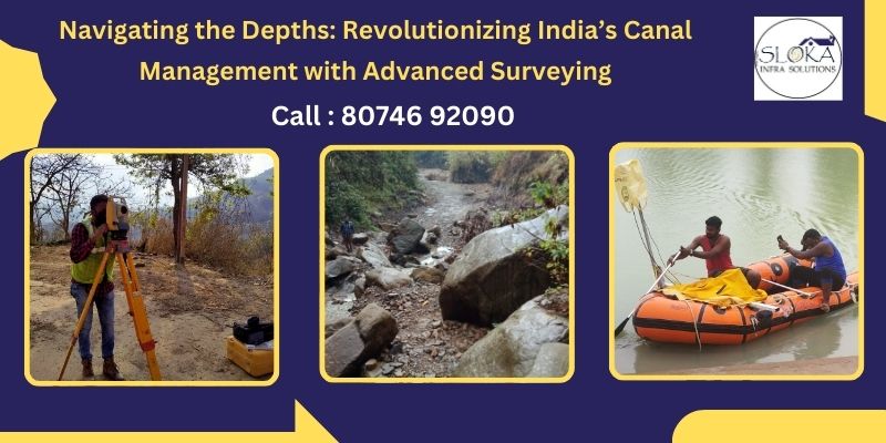
3.2. Core Technologies and Methodologies
- Single‐Beam Echo Sounders: Emit a vertical acoustic pulse to measure depth directly beneath the survey vessel. Simple and cost‐effective for narrow canals, but limited spatial coverage.
- Multi‐Beam Echo Sounders: Emit multiple beams in a fan pattern, covering a wider swath of the bed. Ideal for large canal sections, these systems generate dense point clouds for detailed mapping.
- Side‐Scan Sonar: Produces acoustic images of the canal floor, highlighting features such as submerged vegetation, rocks, or construction debris. When paired with depth data, side‐scan sonar enhances obstacle detection.
- LiDAR Bathymetry: Airborne LiDAR systems—equipped with green lasers—penetrate clear, shallow water to capture both bed and bank elevations. Particularly useful for canals with transparent water and gentle slopes.
- Autonomous Underwater Vehicles (AUVs) & Unmanned Surface Vehicles (USVs): Enable survey operations in hazardous, hard-to-access sections—reducing risks to personnel and providing consistent, repeatable data.
3.3. Data Processing and Visualization
Raw acoustic returns undergo corrections for vessel motion, water temperature, salinity, and sound speed variations. Specialized software integrates these adjustments to produce point clouds, mesh models, and contour maps. Advanced Geographic Information Systems (GIS) overlay bathymetric data with satellite imagery, cadastral maps, and infrastructure layers—facilitating holistic planning.
3.4. Applications of Bathymetric Data in Canals
- Dredging Optimization: Quantify sediment volumes and plan precise dredging operations, reducing costs and minimizing environmental disturbance.
- Scour Assessment: Detect deep scour pits near hydraulic structures—such as weirs and sluice gates—and design protective measures.
- Sediment Transport Studies: Model sediment movement under varying flow regimes, predicting future deposition zones.
- Hydraulic Modeling: Calibrate computational fluid dynamics (CFD) models for accurate simulation of flow velocities and water surface profiles.
4. Understanding Hydrographic Surveys
4.1. Definition and Scope
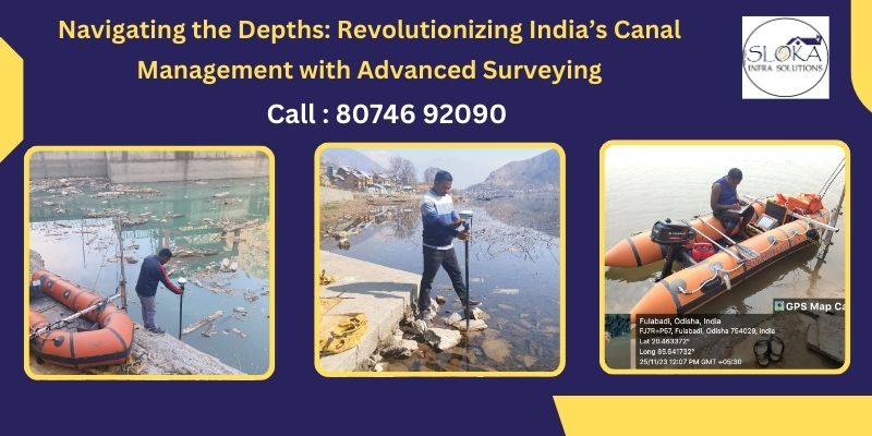
Hydrographic surveys extend beyond depth measurement to capture the interplay between water bodies and their adjacent environments. For canals, this means mapping bank profiles, measuring flow velocities, sampling water quality, and documenting infrastructure elements—such as embankments, culverts, and retaining walls.
4.2. Core Technologies and Techniques
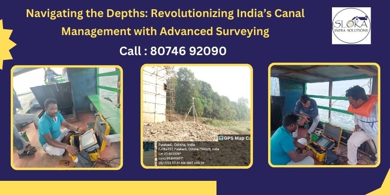
- Total Stations & Terrestrial LiDAR Scanners: Precisely capture bank elevations, bank-line geometry, and nearby topography—ensuring seamless integration with underwater data.
- Acoustic Doppler Current Profilers (ADCPs): Measure flow velocity profiles across depth, essential for understanding conveyance capacity and optimizing gate operations.
- Water Quality Sensors: Continuously record parameters like turbidity, dissolved oxygen, pH, and temperature—critical for detecting pollution and assessing ecological health.
- Unmanned Aerial Vehicles (UAVs): Provide high-resolution aerial imagery of canal corridors, capturing vegetation encroachment, illegal dumping, and structural anomalies.
4.3. Applications of Hydrographic Data in Canals
- Navigation Charts: Produce up-to-date canal brochures for inland water transport authorities—pinpointing danger zones and defining navigable channels.
- Bank Stability Analysis: Identify erosion hotspots and design protective measures—such as geotextile reinforcement or vegetation buffers.
- Floodplain Mapping: Delineate adjacent flood-prone areas, informing land-use planning and emergency response strategies.
- Environmental Monitoring: Track pollution events, algal blooms, and ecosystem shifts—enabling timely remediation actions.
5. Comparative Analysis: Bathymetric vs. Hydrographic Surveys in Canals
| Aspect | Bathymetric Surveys | Hydrographic Surveys |
| Primary Focus | Underwater topography (depth, bed features) | Combined underwater & terrestrial features |
| Key Technologies | Echo sounders, side-scan sonar, LiDAR | ADCPs, total stations, water quality sensors, UAVs |
| Data Outputs | Depth contours, DEMs, sediment models | Navigation charts, bank profiles, flow velocity maps |
| Core Applications | Dredging, scour assessment, hydraulic modeling | Navigation safety, floodplain mapping, environmental monitoring |
| Integration Potential | Integrates into hydrographic datasets | Provides context for bathymetric data |
Despite their distinct focuses, both survey types are inherently complementary. Integrating high-resolution bathymetric models into hydrographic workflows yields a complete understanding of canal dynamics—enabling data-driven canal management that balances infrastructural needs, navigational safety, and ecological sustainability.
6. Key Applications in Canal Management
6.1. Precision Dredging and Maintenance
With targeted bathymetric maps, maintenance teams can prioritize dredging in sections where sediment accumulation threatens conveyance. This targeted approach reduces operational costs, minimizes environmental disturbances, and extends intervals between dredging cycles.
6.2. Safe and Efficient Inland Navigation
Updated hydrographic charts help canal authorities set safe operating guidelines for vessel drafts, speed limits, and lock operations. Real-time flow measurements from ADCPs inform captains of ideal transit windows—avoiding low-water hazards or strong currents that could lead to groundings.
6.3. Flood Risk Reduction
Combining depth profiles with bank stability data allows hydraulic modelers to simulate extreme flow scenarios. Authorities can then design spillways, relief channels, and emergency bypasses—keeping populated areas safe during unprecedented flood events.
6.4. Sustainable Irrigation Management
Flow velocity and water quality data guide precise water allocation in canal networks—minimizing seepage losses and ensuring equitable distribution to tail-end farmers. This precision enhances crop productivity and reduces conflicts over water rights.
6.5. Ecological Conservation
By mapping submerged vegetation zones and monitoring pollutants, hydrographic surveys support habitat restoration projects. Canal sections with endangered fish species or migratory bird habitats can be designated as conservation zones—restricting dredging or bank development.
7. Role of Sloka Infra solutions in Advancing Canal Surveys
Leading firms like Sloka Infra solutions have been instrumental in elevating canal surveying standards across India. By integrating multi-beam sonar, UAV-based aerial mapping, and AI-driven data processing, they deliver turnkey survey packages tailored to each canal’s unique challenges—be it high sediment loads in the Ganges Canal or saline intrusion in the Indira Gandhi Canal. Their collaborative approach—with government agencies, research institutions, and local stakeholders—ensures that survey insights translate into effective maintenance plans, policy frameworks, and sustainable management practices.
8. Technological Advancements and Future Trends
8.1. Autonomous Survey Platforms
The next wave of canal surveys will see wider adoption of AUVs and USVs equipped with multi-sensor suites—operating continuously to track morphological changes and detect anomalies in real time.
8.2. Edge Computing and Real-Time Analytics
In-field processing of acoustic and LiDAR data will enable surveyors to validate data quality on the go—allowing immediate adjustments to survey parameters and reducing post-processing bottlenecks.
8.3. Immersive Visualization
Augmented reality (AR) and virtual reality (VR) tools will let planners “walk” along virtual canal corridors—interacting with 3D models of underwater features, bank profiles, and infrastructure elements before ground interventions.
8.4. Eco-Friendly Survey Practices
Solar-powered survey vessels, biodegradable sensor housings, and non-invasive acoustic techniques will minimize the ecological footprint of mapping operations—aligning with growing environmental regulations.
8.5. Open Data Platforms
Centralized repositories—managed by water ministries and academic consortia—will democratize access to canal survey data, fostering innovation in analytics, machine-learning applications, and community-driven monitoring initiatives.
9. Challenges and Mitigation Strategies
| Challenge | Mitigation Strategy |
| Dynamic Sedimentation & Bank Erosion | Frequent repeat surveys; integration of multi-sensor data |
| Acoustic Signal Interference | Hybrid methods (LiDAR + sonar) for cross-validation |
| Unsafe/Hazardous Survey Zones | Autonomous vehicles; remote sensing via UAVs |
| Large Data Volumes & Processing Needs | High-performance computing; AI-driven data filtering |
| Equipment Calibration & Maintenance | Rigorous QA/QC protocols; regular training for operators |
10. Case Studies and Real-World Applications
10.1. Ganges Canal Modernization
A joint project by state authorities and private surveyors utilized multi-beam bathymetry and ADCPs to redesign weir heights, optimize sluice gate operations, and restore navigability. Post-survey interventions reduced waterlogging in adjacent fields by 30% and improved water delivery reliability during peak irrigation months.
10.2. Indira Gandhi Canal Salinity Control
Hydrographic surveys—combining water-quality sensors with bank stability mapping—identified zones of saline groundwater intrusion. Targeted bank sealing and canal lining projects, guided by these survey insights, curtailed salinity ingress and revitalized agricultural productivity in arid Rajasthan.
10.3. Urban Canal Revitalization in Kerala
In Kochi’s historic canal network, high-resolution LiDAR bathymetry paired with UAV surveys revealed illegal encroachments and waste disposal sites. Data-driven cleanup campaigns and stakeholder workshops have since restored water quality and reopened sections for eco-tourism.
11. Conclusion
By harnessing the combined power of Bathymetric Survey for Canals in India and Hydrographic Survey for Canals in India, stakeholders unlock a new era of precision water management. Detailed underwater terrain models and comprehensive environmental datasets enable proactive maintenance, informed infrastructure planning, and robust flood resilience. As India’s canal networks evolve to meet 21st-century challenges—climate variability, population pressures, and ecological conservation—the integration of advanced surveying technologies will remain indispensable.
Investments in autonomous survey platforms, real-time analytics, and immersive visualization promise to further elevate canal management practices. Open data initiatives and cross-sector collaborations will ensure that insights flow seamlessly from survey vessels to policy chambers, from engineering offices to farming cooperatives. With this data-driven approach, India can safeguard its historic canal heritage, optimize agricultural and transport benefits, and preserve the rich biodiversity that thrives along these engineered waterways.
In essence, the journey beneath the canal surface is more than a technical exercise—it is a pathway to sustainable development, community wellbeing, and ecological harmony. By embracing cutting-edge bathymetric and hydrographic surveys, India charts a course toward resilient water infrastructure that honors the past while building a prosperous, sustainable future.