Unmanned Surface Vehicle for Bathymetric survey in India
Silent Surveyors: Unmanned Vessels Unlock India’s Underwater Secrets
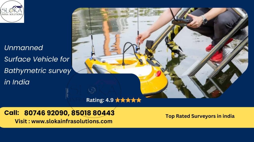
Unmanned Surface Vehicle for Bathymetric survey in India has emerged as a transformative approach to mapping and monitoring the rich and varied aquatic landscapes that define the subcontinent. From the mighty Ganges and Brahmaputra rivers carving fertile plains to the intricate backwaters of Kerala and the vast coastline stretching from Gujarat to Tamil Nadu, India’s waterbodies present both opportunity and challenge for hydrographic exploration. Traditional manned hydrographic vessels often struggle to access shallow, congested, or hazardous zones, yet comprehensive bathymetric data is critical for navigation safety, coastal development, resource management, and environmental protection. In this context, the deployment of small, agile, and cost-effective Unmanned Surface Vehicles (USVs) offers unprecedented flexibility, precision, and efficiency in acquiring depth and floor morphology information, revolutionizing how maritime authorities, researchers, and industry stakeholders understand and manage India’s inland and coastal waters.
Unmanned Surface Vehicle for Bathymetric Surveyor in India
Unmanned Surface Vehicle for Bathymetric Surveyor in India is now an essential tool for governmental agencies, academic institutions, and private enterprises seeking to conduct detailed surveys without the expense and risk of crewed operations. Equipped with echo sounders, GPS positioning systems, inertial navigation units, and sometimes LiDAR or multi-beam sonar, these USVs can autonomously navigate pre-planned transects, collect high-resolution depth measurements, and adapt to changing conditions in real time. Their shallow draft and compact footprint enable them to operate close to shorelines, in narrow channels, beneath bridges, and around submerged obstacles—areas where larger vessels cannot venture. Moreover, by automating repetitive surveying tasks, USVs reduce human exposure to hazards such as strong currents, contaminated waters, or adverse weather, all while delivering consistent, centimeter-level accuracy.
Key Advantages of USVs for Bathymetric Surveys
1.Enhanced Safety and Accessibility
- No crew on board: eliminates risk of drowning, collision, or exposure to pollutants.
- Maneuverable in confined waters: ideal for harbors, lagoons, rivers with sandbars, and reservoirs.
2.Cost Efficiency
- Lower operational costs: reduced fuel consumption and personnel expenses.
- Rapid deployment: minimal launch and recovery infrastructure needed.
3.High-Resolution Data Acquisition
- Precise echo-sounders and navigation: depth data with sub-meter resolution.
- Integration capability: can carry multiple sensors (e.g., SBES, MBES, LiDAR, water-quality probes).
4.Operational Endurance
- Battery or hybrid power: some platforms support multi-hour missions; solar-assisted systems further extend range.
- Automated path planning: unattended surveys over predetermined grids optimize coverage.
5.Environmental Friendliness
- Low-emission electric propulsion: minimal disturbance to sensitive aquatic habitats.
- Low-noise performance: minimizes disturbance to marine wildlife.
Applications Across India’s Diverse Waterbodies
India’s hydrographic needs span a multitude of settings—from alpine lakes in Himachal Pradesh to the mangrove-lined Sundarbans delta. USVs are applied in:
- Riverine Surveys: Tracking sediment deposition and channel morphology in Ganga, Brahmaputra, Krishna, and Godavari basins to support flood forecasting and navigational charting.
- Coastal Zone Mapping: Charting nearshore bathymetry along long littoral stretches in Gujarat, Maharashtra, Goa, Kerala, Tamil Nadu, and Andaman & Nicobar Islands for port development, beach erosion studies, and coral reef monitoring.
- Reservoir and Lake Monitoring: Bathymetric profiling of irrigation impoundments (e.g., Bhakra, Tehri), urban lakes (e.g., Dal Lake, Hussain Sagar), and ecological hotspots to optimize water storage, dredging operations, and aquatic ecosystem health assessments.
- Harbor and Marina Surveys: Detailed mapping of shipping channels, quay approaches, and berthing areas in major ports (Mumbai, Chennai, Kolkata) and upcoming greenfield facilities, ensuring safe vessel maneuvering and berth allocation.
- Hydropower Intake Assessments: Inspection of upstream siltation patterns at dam intakes (e.g., Sardar Sarovar, Koyna) to schedule timely desilting and maintain generation efficiency.
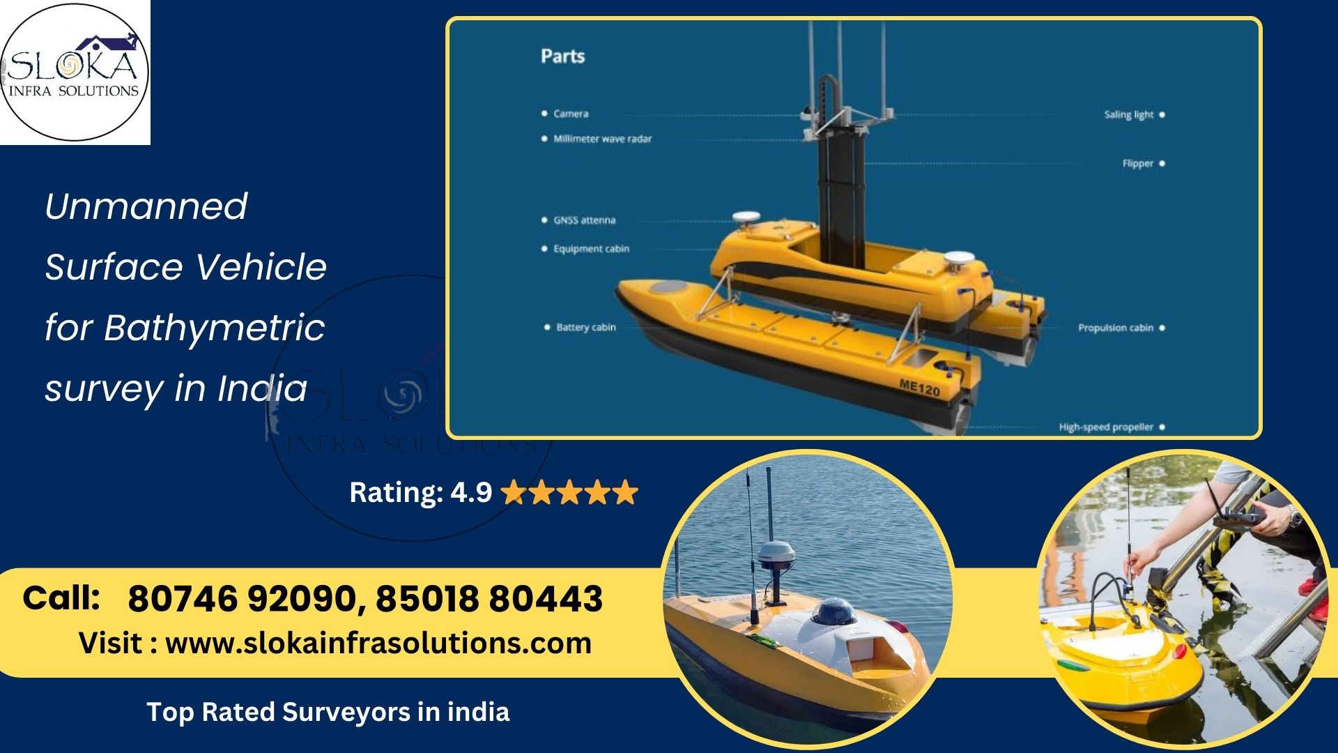
Typical USV Platform Components
1.Hull and Propulsion
- Dotations range from catamaran-style decks to inflatable pontoon designs with twin or quad thrusters for omnidirectional control.
- Electric brushless motors paired with Li-ion or LiFePO₄ battery banks provide quiet, reliable thrust.
2.Navigation and Control
- GNSS receivers (GPS/GLONASS/IRNSS) deliver real-time positioning (often <10 cm accuracy with RTK).
- Inertial Measurement Units (IMU) and digital compasses stabilize heading.
- Onboard autopilots (e.g., Pixhawk, ArduPilot) execute waypoint-based missions and dynamic obstacle avoidance.
3.Bathymetric Sensors
- Single-Beam Echo Sounders (SBES) for point-depth profiling—lightweight and cost-effective.
- Multi-Beam Echo Sounders (MBES) for swath mapping—capture continuous depth slices across vessel track.
- Acoustic Doppler Current Profilers (ADCP) may complement bathymetry with flow measurements.
4.Communications and Data Logging
- Radio telemetry, cellular (4G/5G), or satellite links for live monitoring and remote control.
- Onboard data recorders or SSDs store survey logs, which can later be post-processed with hydrographic software (CARIS, Hypack, QPS).
5.Ancillary Sensors
- Water-quality probes measure turbidity, temperature, salinity, and dissolved oxygen—critical for environmental impact assessments.
- LiDAR altimeters for above-water surface mapping in shallow coastal zones.
Case Study: Inland River Survey in Uttar Pradesh
A recent project along the Ganges in Uttar Pradesh illustrates the strengths of USV-based surveys. Traditional boat crews faced strong mid-channel currents and rapidly changing sandbars, limiting safe access and requiring frequent aborts. Deploying a catamaran USV equipped with an SBES and RTK-GPS, hydrographers autonomously ran pre-programmed transects covering 25 km of river in just two days—half the time and cost of earlier manual surveys. The resulting bathymetric model informed dredging priorities for navigable channels, reducing stranding incidents and enhancing inland water transport efficiency.
Integration with Geographic Information Systems (GIS)
Bathymetric point clouds and seabed models generated by USVs integrate seamlessly into GIS platforms for multidisciplinary analysis:
- Floodplain Zonation: Combining depth with terrain and land-use layers to map flood inundation zones.
- Habitat Suitability Mapping: Linking bathymetry with substrate type and water quality for fisheries and aquatic biodiversity assessments.
- Infrastructure Planning: Overlaying port layouts, pipelines, and cable routes onto detailed seabed maps to optimize alignment and minimize seabed disturbance.
Regulatory and Standardization Considerations
India’s hydrographic practices adhere to guidelines set by the Indian National Hydrographic Office (INHO) and International Hydrographic Organization (IHO) S-44 for survey accuracy. USV operators must ensure:
- Accuracy Standards: Depth measurement uncertainty within prescribed classes (e.g., Order 1A, 1B).
- Metadata Collection: Thorough logging of survey parameters—sound speed profiles, tide levels (referenced to India’s Chart Datum), and vessel motion corrections.
- Safety and Permissions: Coordination with port authorities, local fishermen, and river police to prevent collisions and interference.
Industry Integration and Sustainable USV Advances
In India’s hydrographic sector, service providers are increasingly combining crewed vessels with autonomous USV teams to capitalize on the strengths of both platforms. These hybrid operations streamline survey workflows, allowing large ships to handle broad-area mapping while nimble USVs tackle intricate nearshore or shallow-water zones. Sloka Infra solutions has pioneered solar-assisted USV designs that deliver longer mission durations with minimal environmental impact, pointing the way toward fully self-sufficient, off-grid bathymetric monitoring.
Overcoming Operational Challenges
- Loss of GNSS/Telemetry in Rugged Terrain: Steep river gorges or dense mangrove forests can disrupt satellite signals and radio links. Deploying dual-frequency antennas along with locally established RTK base stations helps maintain reliable positioning and communication.
- Sonar Interference: Floating debris, bubble clouds, and busy traffic introduce acoustic noise that degrades echo sounder returns. Dynamic adjustment of ping rates combined with advanced filtering during post-processing enhances data clarity.
- Power Management Constraints: Careful mission planning must balance the energy needs of propulsion, sensors, and communications. Integrating solar recharging systems and setting up shore-side charging hubs enables multiple sorties per day without lengthy downtime.
Future Trends in USV-Based Bathymetry
- Swarm Surveying: Coordinated fleets of small USVs working in tandem to cover vast water areas rapidly, exchanging real-time data to avoid overlap and maximize efficiency.
- Machine Learning for Feature Detection: Automated seabed classification—identifying shoals, wrecks, pipelines—directly onboard the USV, enabling adaptive sampling.
- Integrated Energy Solutions: Utilizing a combination of solar panels, wind turbine masts, and fuel cells to support extended autonomous operations lasting several weeks in isolated reservoirs and island regions.
- Deep-Learning Path Planning: Real-time adjustment of survey tracks based on detected anomalies or emergent hazards, reducing human supervision.
Conclusion
Unmanned Surface Vehicle for Bathymetric survey in India is revolutionizing hydrographic science and maritime safety across the nation’s rivers, lakes, and coasts. By combining advanced acoustic sensors, precision navigation, and autonomous control, USVs deliver high-resolution bathymetry with unparalleled safety, speed, and cost-effectiveness. As regulatory bodies update guidelines and technology continues to evolve—embracing swarms, AI-driven mapping, and renewable energy—the future promises even more capable platforms. For stakeholders in port management, flood risk reduction, ecological conservation, and resource exploitation, integrating USVs into survey programs ensures that India’s water resources are charted and stewarded with the accuracy and care demanded by the 21st century.