Bathymetric Survey in Qatar
Call: +91 80746 92090
Understanding the Underwater Terrain: The Role of Bathymetric Surveys in Qatar:-
Bathymetric Survey in Qatar plays a crucial role in understanding the underwater topography of the country’s coastal and offshore waters. As Qatar continues to expand its maritime infrastructure, ports, offshore energy facilities, and coastal developments, accurate mapping of the seabed has become essential for safe navigation, engineering planning, and environmental monitoring. Bathymetric surveys measure water depth and analyze the shape, contours, and features of the seabed using advanced acoustic technologies. These surveys help engineers, hydrographers, marine scientists, and government authorities understand underwater terrain before constructing ports, pipelines, bridges, or offshore platforms.
Qatar is a peninsula surrounded by the waters of the Arabian Gulf, with a coastline stretching roughly 563 km and seabed depths typically ranging from shallow coastal zones to around 60 meters in deeper offshore areas. These waters host important ecosystems such as seagrass beds, coral reefs, and mangrove habitats, making seabed mapping not only important for infrastructure but also for environmental protection. In addition, the country’s growing maritime economy—driven by ports, LNG export terminals, marine tourism, and coastal development—requires precise hydrographic information to ensure vessel safety and sustainable marine planning.
From large ports like Hamad Port to coastal cities such as Al Wakrah and Ras Laffan, bathymetric surveys provide essential data for dredging operations, navigation channel planning, subsea cable routing, and shoreline monitoring. These surveys combine GPS positioning systems, sonar technologies, and sophisticated data processing software to generate detailed bathymetric maps and digital terrain models of the seabed.
Top Bathymetric Survey and Surveyor in Qatar
Top Bathymetric Survey and Surveyor in Qatar services are in high demand due to the country’s massive investment in marine infrastructure and logistics. Qatar’s Ministry of Transport has recently launched large-scale hydrographic survey initiatives aimed at updating nautical charts, identifying underwater hazards, and improving maritime traffic management. These initiatives highlight the importance of professional hydrographic surveyors who use cutting-edge technology to deliver precise seabed data.
Professional bathymetric survey companies in Qatar typically provide services such as hydrographic surveys, dredging support surveys, offshore geophysical investigations, underwater pipeline route surveys, harbor maintenance surveys, and coastal monitoring. Survey teams often consist of hydrographers, marine geophysicists, survey engineers, and GIS specialists who collaborate to gather and interpret underwater data.
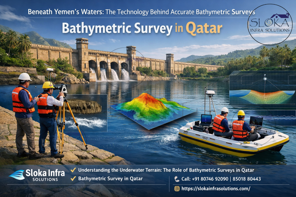
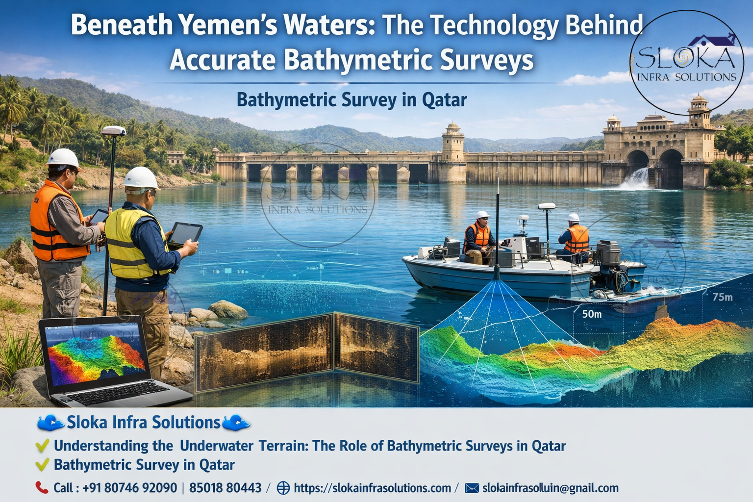
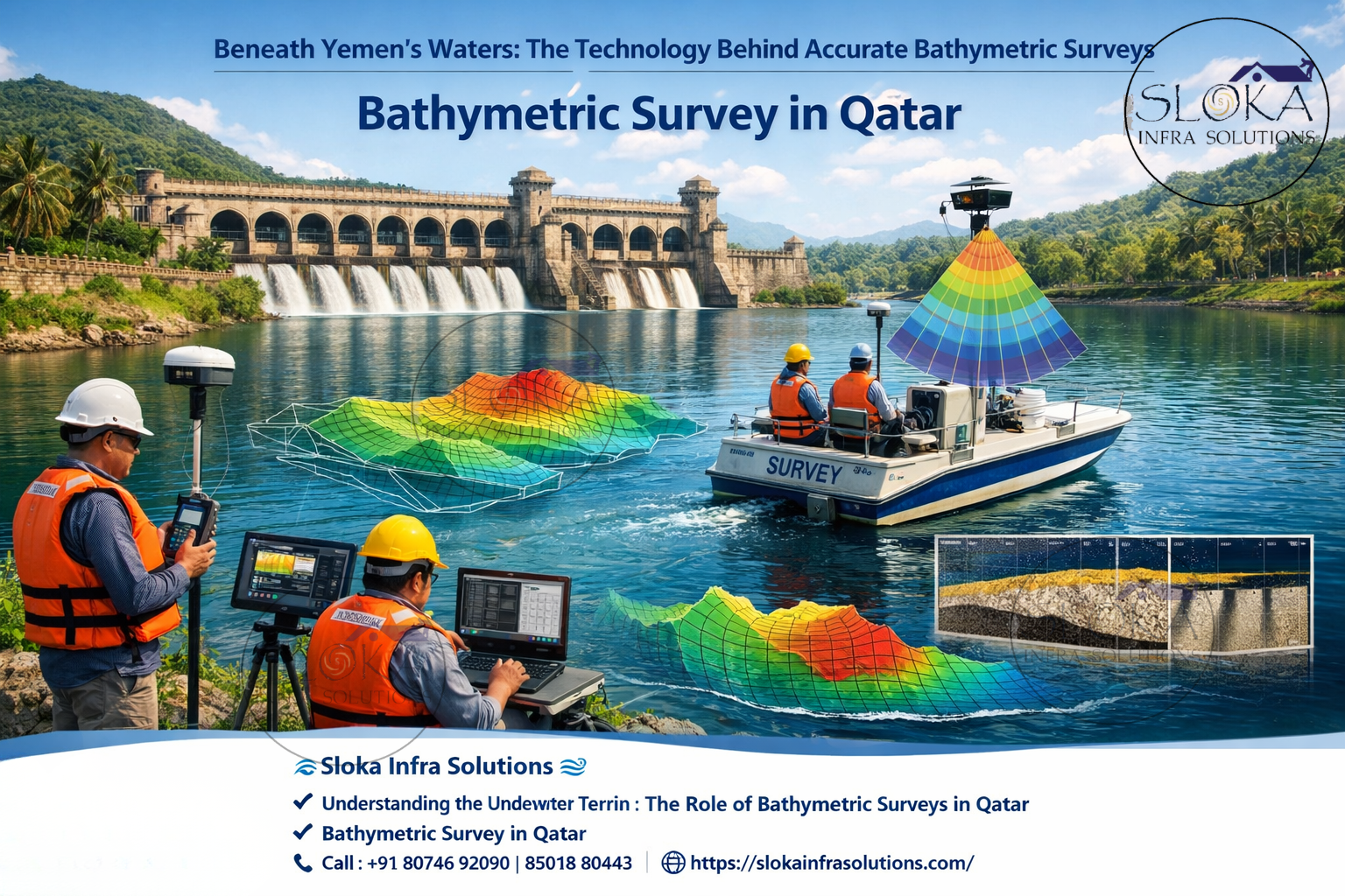
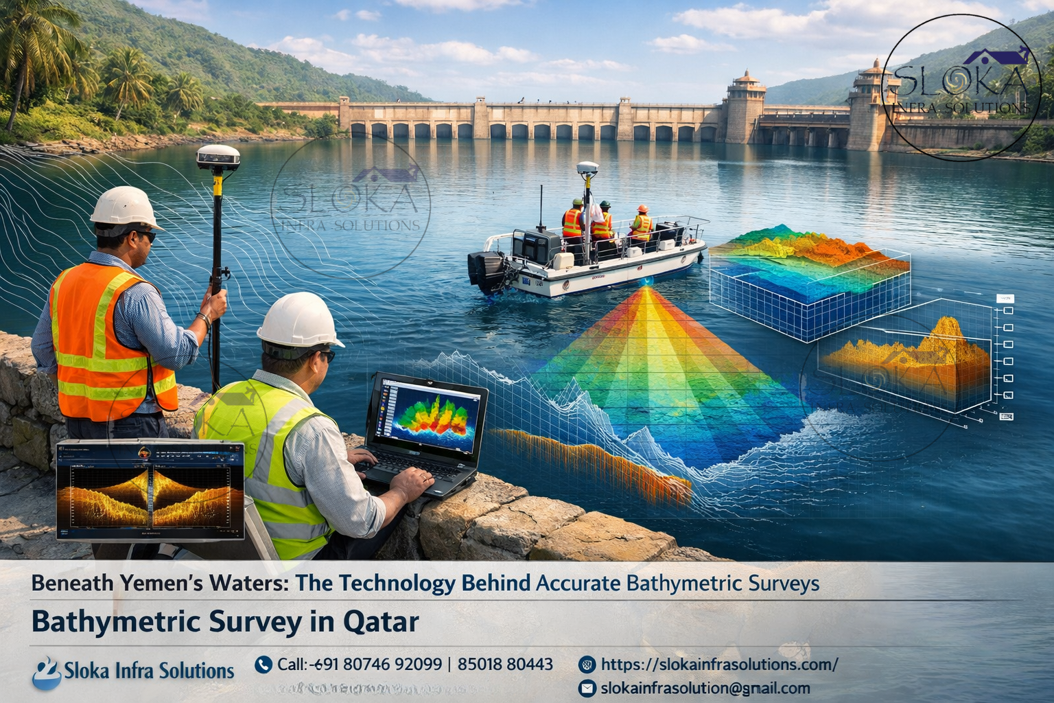
In Qatar’s waters, these surveys are especially important for ports, artificial islands, oil and gas platforms, marine bridges, subsea cable installations, and shoreline protection projects. Modern bathymetric surveys rely on multiple acoustic instruments, including single beam echo sounders, multibeam echo sounders, side scan sonar, sub-bottom profilers, and acoustic Doppler current profilers.
Why Bathymetric surveys are essential in Qatar?
Qatar’s geographic location and coastal development projects make bathymetric surveying a fundamental part of marine engineering. Several factors drive the demand for these surveys across the country.
1.Coastal Infrastructure Development
Qatar has invested heavily in coastal infrastructure including industrial ports, marinas, offshore energy terminals, and waterfront real estate developments. Projects like large commercial seaports require accurate seabed depth mapping before dredging or construction can begin.
2.Safe Navigation
Hydrographic surveys identify underwater obstacles, sandbanks, shipwrecks, and shallow areas that may threaten vessel safety. Updated nautical charts help ships navigate safely through Qatar’s busy maritime routes.
4..Offshore Energy Exploration
Qatar is one of the world’s leading exporters of liquefied natural gas. Offshore pipelines, drilling platforms, and subsea infrastructure require detailed seabed surveys before installation.
5.Environmental Protection
Marine ecosystems such as coral reefs, seagrass meadows, and mangrove forests exist along Qatar’s coast. Bathymetric surveys help scientists understand seabed morphology and protect sensitive habitats.
6.Coastal Zone Management
Survey data helps authorities monitor shoreline changes, erosion, sediment movement, and seabed stability—important factors in coastal planning.
Bathymetric Survey methods used in Qatar:-
Modern bathymetric surveys rely on multiple technologies working together to capture detailed underwater data. Each instrument serves a specific purpose in seabed mapping and marine investigation.
Key technologies include:
- Single Beam Echo Sounder
- Multibeam Echo Sounder
- Side Scan Sonar
- Sub Bottom Profiler
- ADCP Current Surveys
These technologies collectively help create high-resolution bathymetric models and comprehensive hydrographic datasets.
Single Beam Echo Sounder:-
A Single Beam Echo Sounder (SBES) is one of the most widely used instruments in bathymetric surveys, particularly in shallow coastal waters and harbor areas. This system measures water depth by emitting a sound pulse vertically downward from a transducer mounted on a survey vessel. When the sound wave hits the seabed, it reflects back to the receiver. The time taken for the echo to return is used to calculate the depth.
Single beam echo sounders are ideal for surveying rivers, lakes, ports, and coastal channels. Although they collect depth information along a single line directly beneath the vessel, they remain highly effective when combined with precise GPS positioning systems. As the survey vessel moves along predetermined lines, the echo sounder records continuous depth measurements that are later processed to create bathymetric profiles and contour maps.
In Qatar, single beam surveys are commonly used for harbor maintenance, dredging monitoring, pipeline route surveys, and shallow water mapping. Because the Arabian Gulf around Qatar contains many shallow regions and sediment deposits, SBES surveys provide valuable baseline information for marine engineering projects.
Another advantage of single beam systems is their operational simplicity and cost efficiency. They require minimal setup compared to complex multi-sensor systems and can operate in confined waterways where larger survey equipment may not be practical.
Despite their limitations in full seabed coverage, single beam echo sounders remain an essential tool in hydrographic surveying, especially for preliminary investigations and routine depth monitoring in Qatar’s coastal waters.
Multibeam Echo Sounder Surveys:-
Multibeam Echo Sounder (MBES) surveys represent a major advancement in bathymetric mapping technology. Unlike single beam systems that measure depth directly beneath the vessel, multibeam echo sounders emit hundreds of acoustic beams across a wide swath of the seabed. These beams measure depth simultaneously over a broad area, allowing surveyors to capture high-resolution, full-coverage bathymetric data.
Multibeam systems generate detailed three-dimensional models of the seabed, making them ideal for large-scale marine projects. The technology produces dense datasets that reveal seabed slopes, underwater ridges, sand waves, trenches, and other morphological features. Such high-resolution mapping is critical for offshore engineering, pipeline routing, harbor design, and marine habitat studies.
In Qatar, multibeam surveys are frequently used in deepwater port areas, offshore oil and gas fields, and large marine infrastructure projects. Ports such as Hamad Port rely on multibeam bathymetry to maintain navigation channels and monitor sediment accumulation over time.
The system works by transmitting acoustic pulses in a fan-shaped pattern across the seabed. By measuring the travel time of each returning echo and combining it with precise vessel positioning data, the system calculates accurate depth values across the entire swath.
Another benefit of multibeam surveys is their ability to produce seabed imagery and digital terrain models. These models allow engineers to visualize underwater landscapes in three dimensions, improving decision-making during construction and marine planning.
Overall, multibeam echo sounders have revolutionized bathymetric surveying by delivering faster survey coverage, higher accuracy, and more detailed seabed mapping than traditional methods.
Side Scan Sonar:-
Side Scan Sonar is a specialized acoustic imaging technology used to create detailed images of the seabed. Instead of focusing solely on measuring depth, this system captures the texture and features of the seafloor, allowing surveyors to detect objects, structures, and geological formations.
The system works by emitting acoustic pulses sideways from a sonar device known as a towfish. As these sound waves travel across the seabed, they reflect off objects and surface features. The intensity of the returning echoes is recorded and processed to create a continuous image of the seafloor.
Side scan sonar is particularly effective for identifying objects such as shipwrecks, pipelines, debris, submerged rocks, and archaeological artifacts. Because it provides detailed imagery rather than just depth measurements, it is often used alongside multibeam or single beam echo sounders to obtain a complete understanding of seabed conditions.
In Qatar’s coastal waters, side scan sonar surveys are commonly used for pipeline route inspections, harbor clearance surveys, marine archaeology investigations, and environmental habitat mapping. The system is also valuable during dredging operations where detecting underwater obstacles is critical for safety.
One of the key advantages of side scan sonar is its ability to produce photographic-like images of the seabed. These images reveal shadows created by underwater objects, helping surveyors interpret their size and shape.
Because of Qatar’s active maritime traffic and offshore construction projects, side scan sonar plays an important role in detecting potential hazards and ensuring safe navigation channels.
Sub Bottom Profilers:-
Sub Bottom Profilers are advanced geophysical instruments used to study the layers of sediment beneath the seabed. Unlike standard echo sounders that measure the seabed surface, sub-bottom profilers penetrate the seabed and reveal the geological structure below it.
These systems operate by transmitting low-frequency acoustic signals capable of penetrating several meters beneath the seabed. When these signals encounter different sediment layers, part of the energy reflects back to the receiver. The resulting data is processed to create a vertical profile showing sediment layers, buried objects, and geological features.
Sub-bottom profiling is essential for offshore engineering projects that require knowledge of subsurface conditions. For example, when installing offshore pipelines, subsea cables, or drilling platforms, engineers must understand sediment thickness, rock layers, and potential geohazards.
In Qatar’s marine environment, sub-bottom profilers are frequently used during offshore energy development and coastal infrastructure construction. The Arabian Gulf seabed often consists of layers of sand, carbonate sediments, and limestone formations. Understanding these layers is crucial for designing stable foundations for marine structures.
Another important application is in dredging operations. Sub-bottom profiling helps determine sediment composition and thickness, allowing engineers to estimate dredging volumes and identify harder geological layers.
Additionally, the technology supports environmental research by revealing buried coral reefs, ancient shorelines, and sediment deposits formed over thousands of years. These insights help scientists better understand the geological history of Qatar’s marine environment.
By providing a detailed picture of subsurface sediment structures, sub-bottom profilers play a vital role in safe and efficient marine engineering.
ADCP Survey:-
An Acoustic Doppler Current Profiler (ADCP) is a powerful instrument used to measure water current velocity and direction throughout the water column. Unlike traditional depth measuring equipment, ADCP systems analyze the movement of water by using the Doppler effect of sound waves.
The instrument emits acoustic pulses into the water. These pulses reflect off particles suspended in the water, such as sediment or plankton. By analyzing the frequency shift of the returning echoes, the system calculates the speed and direction of water currents at different depths.
ADCP surveys are extremely important in hydrographic and oceanographic studies because water currents directly influence sediment transport, coastal erosion, and vessel navigation. In Qatar’s waters, where tides and currents affect port operations and offshore installations, understanding current patterns is critical.
Survey teams often deploy ADCP instruments from vessels, anchored platforms, or seabed frames. The collected data provides a vertical profile of water movement, allowing researchers to observe how currents vary with depth.
In marine construction projects, ADCP surveys help engineers determine how water flow will affect offshore structures such as bridges, pipelines, and oil platforms. Strong currents can influence sediment movement around foundations, which may impact structural stability.
Additionally, ADCP data is widely used for environmental monitoring and coastal management. It helps scientists track sediment transport pathways, analyze tidal dynamics, and understand how currents influence marine ecosystems.
Because Qatar is surrounded by the Arabian Gulf—an environment characterized by shallow waters and strong seasonal currents—ADCP surveys provide valuable information for navigation safety and marine infrastructure planning.
Guiding Coastal Infrastructure and Waterfront Development:-
Bathymetric surveys support a wide range of marine industries and scientific research activities across Qatar.
1.Port Development
Major ports rely on accurate seabed mapping to maintain safe navigation channels and dredged basins.
2.Offshore Energy Projects
Survey data guides the installation of subsea pipelines, drilling platforms, and offshore structures.
3.Coastal Engineering
Engineers use bathymetric information to design breakwaters, sea walls, and coastal protection structures.
4.Environmental Studies
Marine scientists use bathymetric data to study coral reefs, seagrass habitats, and underwater ecosystems.
5.Marine Archaeology
Underwater imaging technologies help locate historical shipwrecks and cultural heritage sites.
Smart Survey Technologies Transforming Seabed Mapping in Qatar:-
As Qatar continues to develop its maritime infrastructure and expand offshore industries, bathymetric surveying will become even more important. Advances in sonar technology, autonomous underwater vehicles, and artificial intelligence are transforming how seabed data is collected and analyzed.
Modern survey vessels now integrate multiple sensors—including multibeam systems, side scan sonar, and sub-bottom profilers—into a single platform capable of collecting enormous volumes of data in a short time. Autonomous underwater vehicles and remotely operated vehicles are also being used to explore deeper or hazardous areas that are difficult for traditional survey vessels to access.
Furthermore, high-resolution digital seabed models are helping engineers simulate coastal processes, predict sediment movement, and design more sustainable marine infrastructure.
In a rapidly developing maritime nation like Qatar, these technologies ensure that seabed mapping remains accurate, efficient, and environmentally responsible.
Building a stronger future through seabed intelligence:-
Understanding the underwater landscape is crucial for any nation surrounded by the sea, and Bathymetric Survey in Qatar plays a key role in revealing what lies beneath the coastal waters of the Arabian Gulf. These surveys help scientists, engineers, and marine planners study seabed depth, underwater terrain, sediment layers, and water movement with great accuracy. The insights gained from these surveys support safe maritime navigation, sustainable coastal development, and responsible use of marine resources across Qatar’s growing coastal regions.
Modern hydrographic technologies such as Single Beam Echo Sounders, Multibeam systems, Side Scan Sonar, Sub Bottom Profilers, and ADCP instruments have significantly improved the way underwater data is collected and analyzed. With the help of these advanced tools, professionals delivering Top Bathymetric Survey and Surveyor in Qatar services can generate highly detailed seabed maps that assist in offshore energy projects, port expansion, dredging operations, and marine environmental protection.
As Qatar continues to strengthen its position as a global maritime and logistics hub, the need for accurate seabed mapping will become even more important. Continuous advancements in hydrographic technology and marine research will ensure that bathymetric surveying remains a vital part of planning and protecting Qatar’s coastal infrastructure and marine ecosystems for the future.