
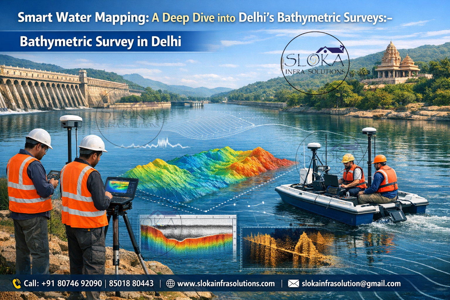
Bathymetric Survey in Delhi
Call: +91 80746 92090
Smart Water Mapping:A Deep Dive into Delhi’s Bathymetric Surveys:-
Bathymetric Survey in Delhi plays a crucial role in understanding the depth, underwater terrain, sediment patterns, and structural conditions of lakes, rivers, reservoirs, and water storage bodies across the capital region. In a city like New Delhi—where rapid urbanization meets historical water systems—accurate underwater mapping is essential for flood control, environmental management, smart city planning, and infrastructure development.
Top Bathymetric Survey and Surveyor in Delhi
Top Bathymetric Survey and Surveyor in Delhi services are in high demand due to increasing needs for dredging assessments, Yamuna riverfront development, reservoir capacity studies, and urban lake rejuvenation projects. From government departments to private infrastructure firms, decision-makers rely on advanced hydrographic technologies to make safe, data-driven engineering and environmental choices.
Understanding Bathymetry: More Than Just Measuring Depth
Bathymetry is the science of measuring underwater depths and mapping submerged terrain. Similar to how topographic surveys map land elevations, bathymetric surveys create detailed 2D and 3D representations of underwater surfaces.
In Delhi, this becomes especially important because of:
- The Yamuna River flowing across the eastern part of the city
- Major reservoirs like Bhalswa Lake
- Historic water bodies such as Hauz Khas Lake
- Flood-prone low-lying regions near Okhla Barrage
Each of these locations has unique sedimentation patterns, depth variations, and hydrological behaviors that require precise underwater mapping.
Why Delhi Needs Advanced Bathymetric Surveys?
Delhi’s geographical and environmental conditions make bathymetric assessments essential:
1. Flood Risk Management
During monsoon seasons, the Yamuna’s water levels rise significantly. Accurate depth data helps authorities predict overflow zones and manage embankments efficiently.
2. Sedimentation Monitoring
Urban runoff carries debris and silt into lakes and reservoirs. Over time, this reduces water storage capacity. Bathymetric surveys help measure sediment accumulation and plan desilting operations.
3. Smart City & Infrastructure Projects
Bridges, metro expansions, stormwater drains, and riverfront beautification require underwater foundation data to ensure structural stability.
4. Environmental Restoration
Projects around areas like Sanjay Lake involve lake rejuvenation, which demands accurate underwater contour mapping.

Technologies Used in Bathymetric Surveys:-
Modern bathymetric surveys combine sonar systems, GPS positioning, motion sensors, and specialized survey vessels. Let’s explore the core technologies used in Delhi’s water bodies.
Single Beam Echo Sounder (SBES):-
The Single Beam Echo Sounder is one of the most widely used systems in bathymetric surveys, especially for rivers and small lakes in urban areas like Delhi.
This system works by emitting a single acoustic pulse vertically downward into the water. When the sound wave hits the bottom surface, it reflects back to the receiver. By calculating the time taken for the signal to return, the system determines the water depth at that exact point.
Why SBES is Useful in Delhi?
- Ideal for shallow water bodies like Hauz Khas Lake
- Effective in narrow river sections of the Yamuna
- Cost-efficient for routine monitoring surveys
- Suitable for sediment level analysis
Although it captures depth data along a single line beneath the survey vessel, when combined with systematic navigation patterns, it creates reliable depth profiles.
For municipal bodies conducting periodic capacity studies of reservoirs, SBES offers a practical and efficient solution.
Multibeam Echo Sounder Surveys (MBES):-
Unlike single beam systems, Multibeam Echo Sounder surveys use multiple acoustic beams spread across a wide swath beneath the vessel. This allows simultaneous depth measurements across a broad area, creating high-resolution 3D seabed maps.
In large water bodies near the Yamuna floodplains or for extensive dredging studies, multibeam systems provide:
- Complete bottom coverage
- Detailed terrain models
- Detection of underwater obstructions
- Accurate volume calculations
For example, when authorities evaluate silt removal projects near the Okhla region, multibeam data helps calculate exact dredging volumes.
MBES is particularly beneficial for:
- River engineering studies
- Bridge foundation planning
- Environmental impact assessments
- Riverfront development mapping
Its precision makes it suitable for high-value infrastructure projects where accuracy cannot be compromised.
Side Scan Sonar:-
Side Scan Sonar is a powerful imaging tool that produces detailed acoustic images of underwater surfaces. Instead of focusing only on depth, it highlights texture, objects, debris, and structural anomalies.
The system emits sound waves sideways from a towfish or hull-mounted device. These waves bounce off underwater objects and return with varying intensities, forming detailed grayscale images.
Applications in Delhi:
In the Yamuna River and reservoirs like Bhalswa Lake, side scan sonar helps in:
- Detecting submerged debris
- Locating abandoned pipelines
- Identifying erosion patterns
- Supporting environmental clean-up drives
For riverfront development or bridge inspection projects, this technology provides visual evidence of underwater conditions.
- Side scan sonar is particularly useful when authorities need to inspect:
- Submerged construction remains
- Solid waste dumping zones
- Underwater vegetation growth
- Structural damage near embankments
Its ability to “see” underwater landscapes makes it an essential tool in urban hydrographic surveys.

Sub Bottom Profilers:-
While echo sounders measure surface depth, Sub Bottom Profilers (SBP) go deeper—literally. They penetrate beneath the river or lake bed to reveal subsurface sediment layers.
The system sends low-frequency acoustic pulses into the bottom. These waves travel through sediment layers and reflect back when they encounter density changes.
Why SBP is Important in Delhi?
In regions near the Yamuna floodplain, sediment deposition changes rapidly due to seasonal flows. Sub bottom profiling helps:
- Identify sediment thickness
- Determine historical deposition layers
- Support foundation design
- Assess dredging feasibility
For large infrastructure projects such as bridge piers or river training structures, understanding subsurface geology is critical.
SBP is also valuable in:
It provides a hidden view beneath the visible riverbed, offering engineers deeper insights for safer design.
Survey Process: Step-by-Step Execution
A professional bathymetric survey in Delhi typically follows these stages:
1. Pre-Survey Planning
- Define project scope
- Review historical hydrological data
- Plan survey lines
- Obtain local permissions
2. Field Data Collection
- Deploy survey vessel
- Calibrate sonar equipment
- Record depth, position, and motion data
- Monitor environmental conditions
3. Data Processing
- Remove noise and errors
- Correct tidal and water level variations
- Generate digital terrain models
4. Final Deliverables
- Contour maps
- 3D models
- Sediment volume calculations
- Engineering reports
Key Applications in Delhi:-
Bathymetric surveys are used for:
- Dredging quantity estimation
- Riverbank stabilization
- Reservoir capacity analysis
- Flood modeling
- Environmental monitoring
- Smart city water planning
Government bodies, irrigation departments, environmental agencies, and private construction firms all rely on these services.
Challenges in Conducting Surveys in Delhi:-
Delhi’s water bodies present unique operational challenges:
- High sediment loads
- Floating debris and waste
- Restricted access zones
- Variable water levels during monsoon
- Dense urban surroundings
Advanced GPS integration and motion correction systems are used to maintain survey accuracy under these conditions.
Importance of Data Accuracy:-
Even small depth measurement errors can lead to:
- Incorrect dredging volume estimates
- Structural instability
- Environmental compliance issues
- Increased project costs
That’s why experienced hydrographic surveyors use calibrated systems, repeat cross-check lines, and follow strict data validation procedures.
Environmental and Sustainability Benefits:-
Accurate underwater mapping supports:
- Lake rejuvenation projects
- Wetland conservation
- Groundwater recharge planning
- Pollution source tracking
By understanding sediment and depth changes, authorities can restore water bodies more effectively.
Emerging Trends in Bathymetric Surveys:-
Modern advancements include:
- Drone-based bathymetric systems
- AI-driven data processing
- Real-time cloud-based monitoring
- Autonomous surface vehicles (ASVs)
These technologies improve efficiency and safety, especially in difficult-to-access zones.
Choosing the Right Survey Partner:-
When selecting a survey provider in Delhi, consider:
- Experience in riverine environments
- Availability of SBES, MBES, SSS, and SBP systems
- Certified hydrographic professionals
- Proven project portfolio
- Compliance with government standards
A skilled team ensures reliable data that supports safe engineering decisions.
Future of Bathymetric Surveying in the Capital:-
As Delhi continues expanding infrastructure and urban water management systems, demand for advanced hydrographic mapping will grow.
From Yamuna river restoration to smart drainage planning, bathymetry will remain central to sustainable development.
The increasing focus on climate resilience and flood mitigation further reinforces the importance of professional underwater mapping services.
Conclusion: Bathymetry as an Integral Urban Tool:-
Bathymetric Survey in Delhi is not just about measuring water depth—it is about enabling smarter infrastructure, safer engineering, and sustainable environmental planning. With advanced tools like Single Beam Echo Sounders, Multibeam systems, Side Scan Sonar, and Sub Bottom Profilers, surveyors can generate precise underwater data that supports critical decision-making.
As projects expand across the Yamuna basin and Delhi’s historic lakes, choosing the Top Bathymetric Survey and Surveyor in Delhi becomes essential for accurate, reliable, and future-ready water resource management.