
Bathymetric Survey in Bahrain
Bathymetric Survey in Bahrain: Tools, Technologies and Experts Mapping the Gulf Seafloor:-
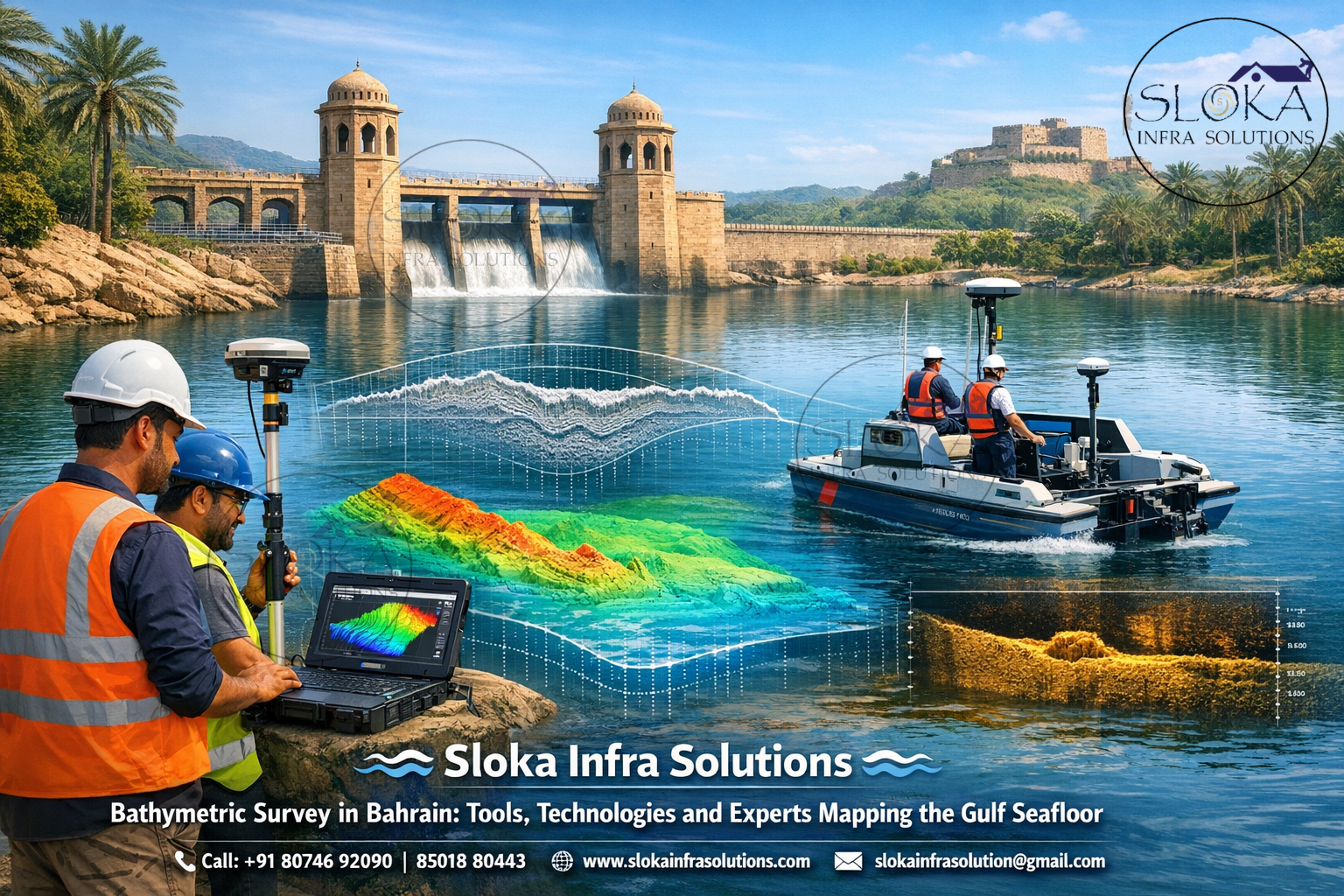
Bathymetric Survey in Bahrain plays a vital role in understanding the underwater landscape of the Kingdom’s coastal and offshore environments. Bahrain is an island nation located in the Arabian Gulf, surrounded by shallow waters, coral reefs, tidal flats, and marine ecosystems that support fisheries, shipping, and offshore energy industries. Because much of the country’s economic and environmental activities depend on marine infrastructure, accurate mapping of the seabed is essential. Bathymetric surveys measure water depth and map underwater terrain using advanced sonar systems, positioning technologies, and geospatial analysis tools.
In Bahrain, these surveys are used for port expansion, dredging projects, subsea cable routing, offshore pipelines, coastal protection planning, and environmental monitoring. From the busy shipping lanes near Khalifa Bin Salman Port to the ecological habitats around Hawar Islands, bathymetric data provides critical insights into seabed morphology. By combining high-resolution sonar equipment with satellite positioning systems, surveyors can generate precise depth charts, three-dimensional seabed models, and detailed hydrographic maps. These datasets support maritime safety, sustainable development, and national marine research initiatives.
Top Bathymetric Survey and Surveyor in Bahrain
Top Bathymetric Survey and Surveyor in Bahrain services are essential for delivering accurate underwater mapping solutions that meet international hydrographic standards. Professional survey companies operating in Bahrain utilize specialized vessels equipped with sonar systems, GPS positioning instruments, motion sensors, and advanced hydrographic software. These technologies allow survey teams to capture millions of depth points across large marine areas, producing highly detailed seabed maps used by engineers, scientists, and maritime authorities.
Surveyors in Bahrain work across multiple sectors including port development, offshore construction, oil and gas exploration, marine environmental studies, and coastal engineering projects. Their expertise ensures that underwater terrain is accurately measured, potential hazards are identified, and infrastructure projects are planned safely. The survey process typically includes pre-survey planning, field data collection, quality control, data processing, and final reporting.
Because Bahrain lies in a relatively shallow gulf with complex seabed formations, professional hydrographic surveyors must also account for tidal variations, sediment movement, coral formations, and human activities such as dredging and land reclamation. By combining traditional hydrographic techniques with modern technologies like multibeam sonar, autonomous survey boats, and drone-based mapping, Bahrain’s survey professionals provide reliable data that supports the nation’s maritime growth and environmental protection.
How modern technology maps the hidden world beneath the water?
Bathymetry refers to the measurement of water depth and the mapping of underwater terrain. Similar to how topographic surveys map the elevation of land surfaces, bathymetric surveys reveal the shape and features of the seabed. This includes underwater hills, valleys, sandbanks, reefs, channels, and man-made structures such as pipelines or shipwrecks.
Modern bathymetric surveys rely on sonar technology, which emits sound waves from a survey vessel toward the seabed. When these sound waves bounce back to the receiver, the time taken for the signal to return is used to calculate the depth of the water. By combining these measurements with high-precision GPS positioning, surveyors can create accurate spatial models of underwater environments.
Bathymetric data is critical for many applications in Bahrain, including:
Safe navigation: Identifying underwater hazards for ships and vessels.
Port development: Supporting dredging and harbor expansion projects.
Offshore energy infrastructure: Mapping seabed conditions for pipelines and cables.
Environmental monitoring: Understanding marine habitats and sediment movement.
Coastal engineering: Designing breakwaters, reclamation projects, and erosion control structures.
The results of a bathymetric survey are typically presented in the form of contour maps, digital elevation models, and 3D seabed visualizations. These outputs help engineers and marine planners make informed decisions about marine infrastructure and environmental management.
Bahrain’s marine geography and the importance of seabed mapping:-
Bahrain’s geography makes hydrographic surveys particularly important. The country consists of more than 30 islands located in the Arabian Gulf, with shallow waters that average around 10–20 meters in depth. The seabed is composed of sandbanks, coral reefs, and limestone formations, which create a dynamic underwater environment.
Major marine areas requiring detailed bathymetric mapping include:
- Bahrain Island Coastline
The main island hosts ports, industrial zones, and urban developments along the coast. Accurate seabed mapping supports harbor maintenance and dredging operations. - Hawar Islands
Located near Qatar, the Hawar archipelago is a protected ecological zone with diverse marine life. Bathymetric surveys help researchers monitor underwater habitats and environmental conditions. - Khalifa Bin Salman Port Area
As Bahrain’s primary commercial port, the surrounding seabed must be regularly surveyed to ensure safe shipping channels and maintain adequate water depth. - Offshore Oil and Gas Fields
Bahrain’s offshore energy infrastructure requires precise seabed mapping to support pipeline installation and maintenance. - Coastal Reclamation Zones
Land reclamation projects have significantly reshaped Bahrain’s coastline over the past decades. Bathymetric surveys help engineers assess sediment movement and seabed stability in these areas.
Because of these geographical factors, hydrographic surveys play an essential role in both economic development and environmental protection.
Measuring water depth with acoustic precision: Technologies used in Bathymetric Surveys:-
Modern bathymetric surveys use a combination of sophisticated technologies to achieve high levels of accuracy. These include:
1.Global Navigation Satellite Systems (GNSS)
Provides real-time positioning for survey vessels, ensuring accurate georeferencing of depth measurements.
2.Motion Sensors and Inertial Measurement Units (IMU)
Compensate for vessel movement caused by waves, ensuring sonar readings remain accurate.
3.Sound Velocity Profilers
Measure the speed of sound in water, which varies depending on temperature, salinity, and pressure.
4.Hydrographic Survey Software
Processes large datasets and generates seabed maps, contours, and 3D models.
These technologies work together to ensure that bathymetric data collected in Bahrain’s waters is precise, reliable, and suitable for engineering and scientific applications.
ADCP Survey (Acoustic Doppler Current Profiler):-
An ADCP Survey is an important hydrographic technique used to measure water current velocities throughout the water column. ADCP stands for Acoustic Doppler Current Profiler, a sonar-based instrument that calculates the speed and direction of moving water using the Doppler effect. This technology is particularly useful in marine environments where currents influence sediment transport, navigation, and offshore construction.
In Bahrain’s coastal waters, ADCP surveys help engineers and researchers understand tidal currents in the Arabian Gulf. Since the region experiences strong tidal flows and seasonal variations, accurate current measurements are essential for planning marine infrastructure such as bridges, ports, and subsea pipelines.
During an ADCP survey, the instrument emits acoustic signals into the water. As these sound waves encounter suspended particles or plankton in the water column, they reflect back to the sensor. By analyzing the frequency shift of the returning signal, the ADCP calculates water velocity at multiple depths simultaneously.
Key applications of ADCP surveys in Bahrain include:
- Studying tidal patterns near ports and harbors
- Assessing current conditions for offshore construction
- Monitoring sediment transport and seabed erosion
- Supporting environmental and marine habitat studies
ADCP instruments can be deployed from boats, mounted on seabed frames, or attached to buoys for long-term monitoring. The collected data helps oceanographers and engineers better understand hydrodynamic conditions in Bahrain’s marine environment, ensuring safe and sustainable coastal development.
Single Beam Echo Sounder Survey:-
A Single Beam Echo Sounder Survey is one of the most widely used methods for measuring water depth in hydrographic surveys. This technique involves transmitting a single acoustic beam directly downward from a survey vessel to the seabed. When the sound wave hits the bottom, it reflects back to the receiver, allowing the system to calculate the depth based on the travel time of the signal.
Single beam echo sounders are particularly useful for smaller survey areas, narrow waterways, and routine hydrographic inspections. In Bahrain, they are commonly used for monitoring dredged channels, harbor basins, and coastal engineering projects.
The survey process typically involves navigating the vessel along predefined survey lines across the study area. As the boat moves, the echo sounder continuously records depth measurements at regular intervals. These measurements are combined with GPS positioning data to create accurate bathymetric profiles.
Advantages of single beam echo sounder surveys include:
- Cost-effective solution for depth measurement
- Suitable for shallow water environments
- Reliable technology with proven accuracy
- Easy integration with GPS and hydrographic software
In Bahrain’s ports and coastal infrastructure projects, single beam surveys help maintain navigational safety by detecting sediment buildup or underwater obstructions. They are also frequently used for preliminary site investigations before more detailed multibeam surveys are conducted.
Although this method measures depth along a single line beneath the vessel, when combined with multiple survey lines it can still provide valuable insights into seabed conditions.
Multibeam Echo Sounder Survey:-
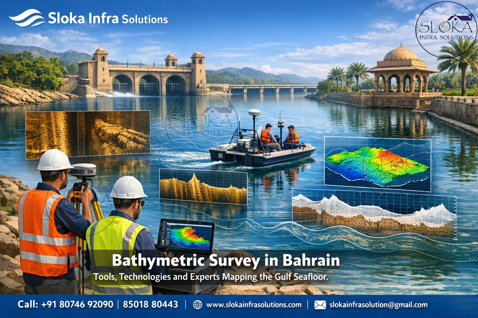
A Multibeam Echo Sounder Survey represents one of the most advanced methods for mapping the seabed. Unlike single beam systems that measure depth directly beneath the vessel, multibeam systems emit multiple sonar beams in a wide fan-shaped pattern across the seabed. This allows surveyors to collect thousands of depth measurements simultaneously.
Multibeam technology produces extremely detailed and high-resolution maps of underwater terrain. It can capture complex seabed features such as ridges, depressions, coral reefs, and underwater structures with remarkable accuracy.
In Bahrain, multibeam surveys are widely used for:
- Port expansion and dredging design
- Offshore pipeline and cable routing
- Coastal zone management
- Marine habitat mapping
- Archaeological exploration of submerged sites
The system works by emitting a swath of acoustic signals across the seabed. Each beam measures depth at a different angle, creating a wide strip of coverage. As the survey vessel moves forward, these strips overlap to form a continuous 3D map of the seabed.
Multibeam data processing involves sophisticated software that corrects for vessel motion, water column variations, and tidal changes. The final results include digital terrain models, contour maps, and color-coded seabed imagery.
Because of its ability to capture detailed seabed morphology, multibeam echo sounding has become the preferred technology for large-scale hydrographic surveys in Bahrain’s offshore and coastal environments.
Side Scan Sonar:-
Side Scan Sonar is a specialized hydrographic technology designed to create detailed images of the seabed surface. Unlike echo sounders that primarily measure depth, side scan sonar focuses on capturing the texture and features of the seafloor.
The system works by emitting acoustic pulses to both sides of a towfish or sonar unit that is either towed behind a vessel or mounted on an autonomous underwater vehicle. As these sound waves strike the seabed, they reflect back with varying intensities depending on the type of material encountered.
In Bahrain’s waters, side scan sonar surveys are commonly used for:
- Detecting underwater objects such as wrecks or debris
- Inspecting pipelines and subsea cables
- Mapping seabed textures and sediment patterns
- Supporting marine archaeological investigations
The sonar system generates detailed grayscale images where different seabed materials produce different levels of acoustic reflection. Hard surfaces like rock appear bright, while soft sediments appear darker.
Side scan sonar is particularly valuable in areas where visual inspection is difficult due to poor underwater visibility. By providing high-resolution imagery of the seabed, it allows surveyors to identify objects and features that may not be visible through depth measurements alone.
Sub Bottom Profilers:-
A Sub Bottom Profiler is an advanced acoustic instrument used to investigate layers beneath the seabed surface. While bathymetric systems measure the top of the seabed, sub bottom profilers penetrate the sediment layers below, revealing geological structures and buried objects.
This technology is especially important in marine engineering projects where understanding the composition and thickness of seabed sediments is essential for safe construction.
In Bahrain, sub bottom profiler surveys are frequently used for:
- Offshore foundation studies
- Pipeline route planning
- Cable installation projects
- Geological and sediment research
The system works by transmitting low-frequency acoustic pulses into the seabed. These signals penetrate the sediment layers and reflect back from boundaries between different materials such as sand, clay, or rock. By analyzing the returned signals, surveyors can create vertical cross-section images of the seabed structure.
These profiles help engineers determine sediment thickness, detect buried objects, and identify geological features that could impact construction activities. In Bahrain’s shallow Gulf waters, sub bottom profiling is particularly useful for understanding sediment movement and long-term seabed stability.

Helping plan dredging, Port expansion, and Harbor maintenance:-
Bathymetric surveys support a wide range of marine and coastal projects across Bahrain.
1.Port and Harbor Development
Regular seabed mapping ensures shipping channels remain safe and navigable.
2.Dredging Operations
Surveys determine the amount of material to be removed and monitor dredging progress.
3.Marine Environmental Studies
Researchers use bathymetric data to study coral reefs and marine ecosystems.
4.Offshore Infrastructure
Seabed mapping guides the installation of pipelines, wind farms, and subsea cables.
5.Coastal Protection
Understanding seabed morphology helps engineers design structures that prevent erosion and flooding.
Emerging technologies transforming seabed mapping in Bahrain:-
The future of bathymetric surveying in Bahrain is closely tied to technological advancements. Autonomous surface vessels, underwater drones, and artificial intelligence-based data analysis are transforming the way marine data is collected and processed.
With increasing investments in coastal development, offshore energy projects, and environmental conservation, demand for high-resolution seabed mapping will continue to grow. Advanced hydrographic technologies will allow surveyors to collect more accurate data in less time while minimizing environmental impact.
Looking Ahead: Smarter and Safer Marine Mapping for Bahrain:-
Bathymetric Survey in Bahrain plays a vital role in understanding and managing the underwater landscape that surrounds the Kingdom. Accurate seabed mapping helps authorities, engineers, and marine experts make informed decisions for safe navigation, coastal infrastructure development, and protection of valuable marine ecosystems. In a nation where the sea supports trade, energy, and environmental resources, reliable bathymetric data becomes the backbone of sustainable maritime growth.
Through advanced technologies such as multibeam echo sounders, side scan sonar, ADCP systems, and sub-bottom profilers, hydrographic professionals can capture detailed information about seabed depth, underwater features, and sediment layers. These technologies provide a clearer picture of Bahrain’s coastal and offshore environments, helping planners design ports, pipelines, reclamation projects, and marine structures with greater accuracy and safety.
As Bahrain continues to develop its maritime economy and expand coastal projects, the role of Top Bathymetric Survey and Surveyor in Bahrain becomes increasingly important. Skilled survey teams equipped with modern instruments ensure high-precision data collection that supports engineering, environmental monitoring, and long-term coastal management.
Looking ahead, bathymetric surveying will remain a key component in shaping Bahrain’s marine future—guiding infrastructure development, safeguarding navigation routes, and supporting sustainable use of the Arabian Gulf’s underwater resources.