Reservoir Bathymetric Survey in India
Why Every Major Dam in India Needs Regular Reservoir Bathymetric Surveys
Call: +91 80746 92090
Reservoir Bathymetric Survey in India has emerged as one of the most important hydrographic practices for sustainable water resource management in a country where reservoirs are the backbone of irrigation, drinking water supply, flood moderation, and hydropower generation. India possesses more than 5,000 large dams and thousands of medium and minor reservoirs spread across diverse geographical settings ranging from the Himalayan foothills to the Deccan Plateau and coastal river basins. Over time, these reservoirs undergo continuous changes due to sediment deposition, erosion, fluctuating water levels, and human interventions. Understanding these underwater changes is essential to maintain storage efficiency, operational safety, and long-term infrastructure performance. Reservoir bathymetric surveys provide the scientific foundation required to accurately map submerged terrain, assess storage losses, and support informed decision-making for reservoir management.
Reservoir Bathymetric Surveyor in India
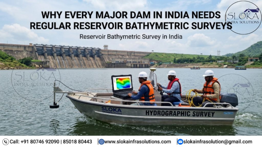
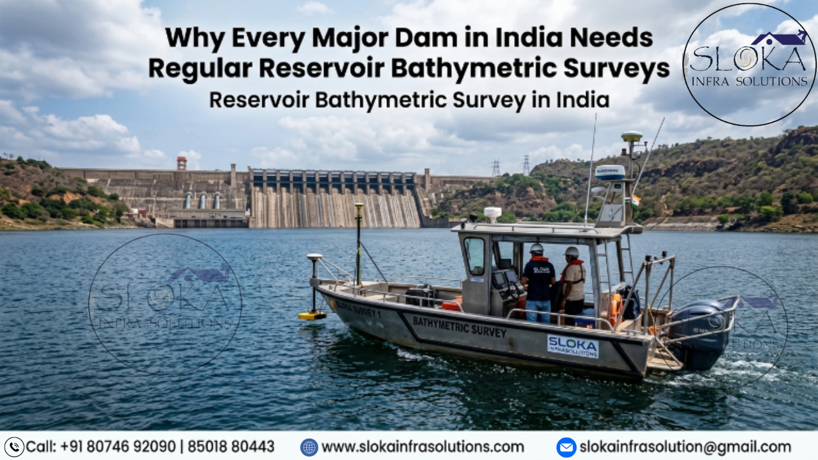
Reservoir Bathymetric Surveyor in India plays a vital role in evaluating the underwater condition of reservoirs through the integration of advanced hydrographic technologies, geospatial tools, and engineering expertise. These specialists collect precise depth measurements, analyze sediment distribution patterns, prepare digital terrain models, and generate updated elevation-capacity relationships for reservoir operators and government agencies. Using technologies such as Single Beam Echo Sounders, Multibeam Echo Sounders, ADCP systems, Side Scan Sonars, Sub Bottom Profilers, DGPS, GIS, and specialized hydrographic software, surveyors deliver highly accurate information that supports dam safety assessments, desiltation planning, hydropower optimization, and environmental monitoring. Their work ensures that India’s water infrastructure continues to perform efficiently despite increasing pressures from climate variability and sedimentation.
Why Reservoir Bathymetric Surveys Are Becoming Increasingly Important?
India’s reservoirs are exposed to varying climatic and geological conditions. Reservoirs situated in Himalayan catchments receive enormous sediment loads due to steep slopes, landslides, glacier melt, and intense rainfall events. In contrast, reservoirs located in central and southern India are affected by monsoon-induced soil erosion, watershed degradation, agricultural runoff, and deforestation.
Sediment entering a reservoir gradually settles on the bed, reducing storage capacity and altering underwater morphology. If this process remains unchecked, reservoirs may lose a significant portion of their designed storage volume, adversely affecting irrigation supplies, drinking water availability, and power generation.
Regular bathymetric surveys enable reservoir authorities to:
- Quantify existing storage capacity.
- Measure annual sediment accumulation rates.
- Identify critical sediment deposition zones.
- Update reservoir area-capacity curves.
- Support dam rehabilitation programs.
- Plan dredging and desiltation activities.
- Improve flood forecasting and reservoir operations.
- Ensure safe functioning of intake structures and spillways.
Periodic underwater surveys have therefore become indispensable for the effective management of major Indian reservoirs such as Bhakra, Hirakud, Tehri, Sardar Sarovar, Nagarjuna Sagar, Indira Sagar, Tungabhadra, and numerous state-owned irrigation projects.
Understanding Sedimentation Processes in Indian Reservoirs:-
Sedimentation is the single most significant factor responsible for reducing reservoir life. Rivers naturally transport sediments in the form of clay, silt, sand, gravel, and organic matter. When flowing water enters a reservoir, flow velocity decreases considerably, causing suspended particles to settle on the reservoir floor.
The rate and pattern of sediment deposition depend upon several factors:
- Catchment geology and soil characteristics.
- Rainfall intensity and monsoon variability.
- Land use and agricultural practices.
- Deforestation and urban development.
- River discharge and flow regime.
- Reservoir geometry and operational practices.
- Upstream erosion processes.
Sediment deposition generally begins in the upstream reaches of reservoirs and gradually advances toward the dam. In many Indian reservoirs, sediment accumulation has already reduced both live storage and dead storage capacities, highlighting the necessity for frequent hydrographic assessments.
Workflow of a Reservoir Bathymetric Survey:-
Modern reservoir bathymetric surveys follow a systematic workflow to ensure accuracy and consistency.
Pre-Survey Planning
Before field operations begin, hydrographic teams establish survey objectives and prepare comprehensive operational plans.
Planning activities typically include:
- Defining reservoir boundaries.
- Reviewing historical survey records.
- Identifying benchmark stations.
- Designing navigation transects.
- Selecting appropriate survey technologies.
- Assessing weather and water-level conditions.
- Obtaining regulatory permissions.
Historical contour maps, satellite imagery, engineering drawings, and previous capacity studies are carefully reviewed to understand long-term reservoir changes.
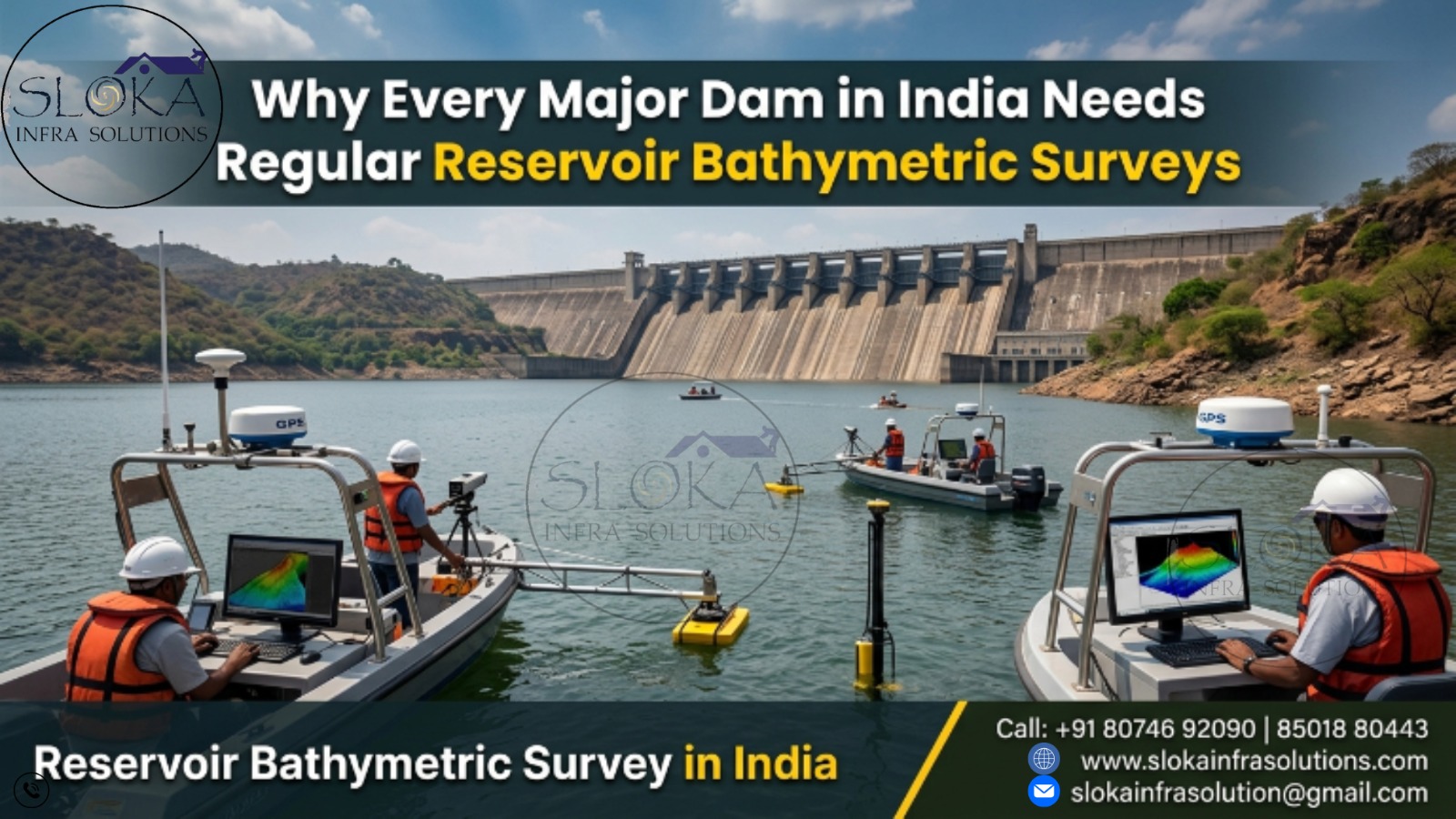
Field Data Acquisition
During field operations, specialized survey vessels navigate along predetermined survey lines across the reservoir.
Simultaneously, multiple instruments record:
- Water depth measurements.
- Geographic coordinates.
- Bottom characteristics.
- Water current information.
- Sediment thickness data.
- Underwater imagery.
All sensors are synchronized with DGPS or RTK GNSS systems to ensure centimeter-level positional accuracy.
Data Processing and Interpretation
Raw hydrographic observations undergo extensive quality control and correction procedures.
These include:
- Water-level corrections.
- Sound velocity adjustments.
- Vessel motion compensation.
- Position corrections.
- Noise filtering.
- Data validation.
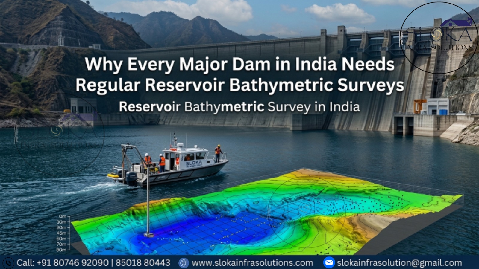
The processed datasets are then transformed into:
- Bathymetric contour maps.
- Digital Elevation Models (DEM).
- Three-dimensional terrain models.
- Reservoir capacity curves.
- Sedimentation distribution maps.
- Cross-sectional profiles.
These deliverables provide reservoir managers with an accurate representation of existing underwater conditions.
1.Single Beam Echo Sounder Survey: The Foundation of Reservoir Capacity Assessment:-
Single Beam Echo Sounder (SBES) technology remains one of the most widely adopted methods for reservoir surveys because of its reliability, cost-effectiveness, and operational efficiency. Numerous reservoir studies in India have successfully utilized Single Beam systems to evaluate storage loss and sedimentation patterns.
A Single Beam Echo Sounder emits an acoustic pulse vertically beneath the survey vessel. The time taken for the signal to travel to the reservoir bed and return is converted into depth measurements.
Survey vessels move along predefined grid lines covering the entire reservoir area. Thousands of depth points collected during the survey are combined with precise positioning data to generate underwater terrain models.
Single Beam surveys offer several advantages:
- Rapid deployment over large areas.
- Economical operation.
- Reliable storage estimation.
- Effective long-term monitoring.
- Suitability for periodic sedimentation studies.
For large reservoirs covering hundreds of square kilometers, Single Beam surveys remain the preferred approach for updating reservoir capacity and assessing storage depletion.
2.Multibeam Echo Sounder Survey: Achieving Complete Underwater Coverage:-
Multibeam Echo Sounder (MBES) technology has transformed reservoir mapping by providing near-complete coverage of the underwater surface.
Unlike Single Beam systems that measure only one point beneath the vessel, Multibeam systems transmit numerous acoustic beams in a fan-shaped pattern across the reservoir floor. Each acoustic ping generates hundreds of depth measurements simultaneously.
This approach produces highly detailed and continuous representations of underwater terrain.
Multibeam surveys are particularly beneficial for:
- High-resolution bathymetric mapping.
- Detailed sediment morphology analysis.
- Dam safety investigations.
- Scour assessment near hydraulic structures.
- Underwater infrastructure inspections.
- Three-dimensional visualization.
Critical zones surrounding dam faces, intake towers, spillways, and sediment deltas can be mapped with exceptional precision.
The ability of MBES systems to generate dense point clouds significantly improves engineering analysis and reservoir management decisions.
3.ADCP Survey: Understanding Water Movement and Sediment Transport
Acoustic Doppler Current Profiler (ADCP) surveys provide valuable information about water circulation patterns inside reservoirs.
An ADCP transmits acoustic signals into the water column and measures frequency shifts produced by moving suspended particles. This principle enables the instrument to calculate water velocity and flow direction at multiple depths simultaneously.
Reservoir current information is essential because water movement directly influences sediment transport and deposition.
ADCP surveys help engineers:
- Analyze inflow and outflow characteristics.
- Study sediment transport mechanisms.
- Assess circulation patterns.
- Optimize hydropower intake performance.
- Evaluate environmental flows.
- Support flood routing studies.
During monsoon periods, reservoirs experience significant changes in hydrodynamic behavior. ADCP investigations provide critical insights into these seasonal variations and assist reservoir operators in developing effective water-release strategies.
Integrating ADCP data with bathymetric information creates a comprehensive understanding of reservoir processes and improves operational efficiency.
4.Side Scan Sonar: Visualizing the Reservoir Floor
Side Scan Sonar technology produces high-resolution acoustic images of the reservoir bed, enabling survey teams to identify underwater features that cannot be detected through depth measurements alone.
The system transmits acoustic pulses sideways across the reservoir floor. Variations in reflected acoustic energy create detailed images resembling aerial photographs of submerged terrain.
Side Scan Sonar surveys can detect:
- Sunken debris.
- Submerged trees.
- Rock outcrops.
- Sediment textures.
- Scour holes.
- Underwater obstructions.
- Dam intake blockages.
- Abandoned structures.
Indian reservoirs often contain submerged remnants of villages, vegetation, and construction debris left behind after impoundment. Such features may interfere with dredging activities, navigation, or infrastructure operations.
Side Scan Sonar therefore plays a critical role during reservoir rehabilitation projects, intake inspections, and underwater construction planning.
The technology substantially reduces the need for diver interventions while improving safety and survey efficiency.
5.Sub Bottom Profilers: Looking Beneath the Reservoir Floor
While conventional bathymetric systems map the visible reservoir bed, Sub Bottom Profilers investigate what lies beneath accumulated sediments.
Sub Bottom Profilers emit low-frequency acoustic signals capable of penetrating sediment layers and reflecting from buried geological interfaces.
The resulting profiles reveal:
- Sediment thickness.
- Buried river channels.
- Historical reservoir bed elevations.
- Geological formations.
- Sediment stratification.
- Subsurface anomalies.
This information is extremely valuable for estimating total sediment accumulation and determining remaining reservoir life.
Many Indian reservoirs have been operational for decades, making subsurface sediment analysis essential for future rehabilitation planning.
Sub Bottom Profilers support:
- Sedimentation studies.
- Desiltation planning.
- Reservoir capacity reassessment.
- Geological investigations.
- Dam rehabilitation programs.
By integrating Sub Bottom Profiling with conventional bathymetric surveys, engineers gain a complete understanding of both surface and buried sediment conditions.
Emerging Trends in Reservoir Hydrographic Surveying:-
Reservoir surveys are rapidly evolving due to technological innovation.
Some emerging developments include:
- Autonomous Unmanned Surface Vehicles (USVs).
- Artificial Intelligence-based data processing.
- Drone-assisted shoreline mapping.
- Cloud-enabled hydrographic workflows.
- Real-time reservoir monitoring systems.
- Digital twin technology.
- Advanced GIS and BIM integration.
These innovations are expected to significantly enhance survey accuracy, reduce field time, and improve decision-making for water resource managers.
Conclusion:-
India’s reservoirs are strategic national assets that support agriculture, drinking water supply, hydropower generation, industry, and flood control. However, increasing sedimentation and changing hydrological conditions continue to threaten their long-term sustainability. Comprehensive underwater investigations are therefore essential to accurately evaluate reservoir health, storage availability, and sediment distribution. Modern technologies such as Single Beam Echo Sounders, Multibeam Echo Sounders, ADCP systems, Side Scan Sonars, and Sub Bottom Profilers provide the scientific foundation required for informed reservoir management. As water security becomes increasingly important, Reservoir Bathymetric Survey in India and Reservoir Bathymetric Surveyor in India services will remain indispensable for safeguarding the nation’s valuable water resources and ensuring sustainable infrastructure performance for generations to come.