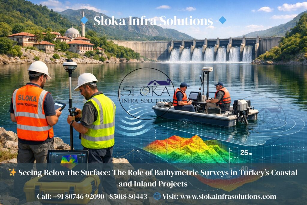
Bathymetric Survey in Turkey
Seeing Below the Surface: The Role of Bathymetric Surveys in Turkey’s Coastal and Inland Projects:-
Call: +91 80746 92090
Bathymetric Survey in Turkey plays a vital role in understanding, managing, and protecting the country’s diverse underwater landscapes. Positioned at the crossroads of Europe and Asia, Turkey is surrounded by the Black Sea, Aegean Sea, and Mediterranean Sea, while also hosting inland seas, strategic straits, large lakes, reservoirs, and extensive river systems. From busy international shipping routes such as the Bosphorus and Dardanelles to inland dams supporting agriculture and hydropower, accurate underwater mapping is essential for navigation safety, infrastructure planning, environmental protection, and sustainable water resource management.
A bathymetric survey is the science and technology of measuring water depths and mapping the shape of the seabed, lakebed, or riverbed. Similar to how topographic surveys represent land elevations, bathymetric surveys reveal what lies beneath the water surface. In Turkey, where seismic activity, sediment transport, and coastal dynamics continuously reshape underwater terrain, bathymetric data becomes even more valuable. These surveys provide high-resolution insights into underwater slopes, channels, sediment layers, and potential hazards, forming the foundation for marine engineering, coastal development, and environmental monitoring projects.
Bathymetric Surveyor in Turkey
Bathymetric Surveyor in Turkey refers to a trained professional or specialized team responsible for planning, executing, processing, and delivering underwater survey data tailored to Turkey’s unique geographic and regulatory conditions. Operating across seas, lakes, rivers, reservoirs, and ports, these professionals combine hydrographic expertise with modern geospatial technologies to produce accurate, reliable bathymetric models.
A bathymetric surveyor’s responsibilities go far beyond depth measurement. They analyze tides and currents in the Turkish Straits, account for wave climates along the Aegean and Mediterranean coasts, and adapt methodologies for shallow inland waters such as Lake Van, Lake Tuz, and hundreds of irrigation reservoirs across Anatolia. By collaborating with engineers, environmental scientists, port authorities, and government agencies, surveyors ensure that bathymetric outputs support real-world decision-making, from bridge construction and dredging to habitat conservation and flood risk mitigation.
Turkey’s Diverse Waterbodies and the Need for Bathymetric Surveys:-
Turkey’s geography is exceptionally varied, making bathymetric surveying both challenging and essential. The country’s waterbodies can be broadly categorized into marine, coastal, and inland systems, each with distinct survey requirements.
1.Marine and Coastal Waters
Turkey’s coastline stretches over thousands of kilometers, encompassing three major seas with very different characteristics. The Black Sea features deeper basins and limited tidal influence, the Aegean Sea is known for its complex island-dotted bathymetry and tectonic activity, and the Mediterranean Sea combines deep offshore waters with rapidly changing nearshore zones. Bathymetric surveys in these areas support port development, offshore energy projects, cable and pipeline routing, and maritime safety.
2.Straits and Strategic Channels
The Bosphorus and Dardanelles are among the busiest and most sensitive waterways in the world. Narrow widths, strong currents, and heavy vessel traffic make precise bathymetric information critical. Even small changes in seabed morphology can affect navigation safety, anchoring zones, and emergency response planning.
3.Inland Lakes, Rivers, and Reservoirs
Beyond the coast, Turkey relies heavily on inland water resources. Large lakes, seasonal rivers, and man-made reservoirs are central to drinking water supply, agriculture, flood control, and hydropower generation. Sedimentation, water level fluctuations, and erosion can significantly alter underwater terrain over time. Regular bathymetric surveys help authorities assess storage capacity, plan dredging, and ensure long-term water security.
Essential Survey Technologies for Mapping Underwater Terrain:-
Modern bathymetric surveys rely on a suite of acoustic and positioning technologies. The selection of tools depends on water depth, survey objectives, environmental conditions, and required accuracy.
Single Beam Echo Sounder Survey
A single beam echo sounder is one of the most widely used tools in bathymetric surveying, particularly for shallow waters and smaller-scale projects. This system emits a single acoustic pulse vertically downward from a transducer mounted on a boat or unmanned surface vessel. The sound wave travels to the seabed, reflects back, and the time taken for the return signal is converted into depth.
In Turkey, single beam echo sounder surveys are commonly used in reservoirs, rivers, canals, and nearshore areas where water depths are relatively uniform and access may be limited. These surveys are cost-effective and efficient, making them suitable for routine monitoring, volume calculations, and preliminary assessments.
While single beam systems provide depth information directly beneath the vessel, they do not capture the full seafloor between survey lines. As a result, careful line planning and interpolation are required to generate continuous bathymetric surfaces. When combined with high-accuracy GNSS positioning and sound velocity corrections, single beam surveys can still deliver reliable results for many inland and coastal applications.
Multibeam Echo Sounder Surveys
Multibeam echo sounder surveys represent a significant advancement in bathymetric mapping. Unlike single beam systems, multibeam echo sounders emit a fan-shaped array of acoustic beams that cover a wide swath of the seafloor with each pass. This allows surveyors to capture dense, high-resolution depth data across large areas efficiently.
In Turkish waters, multibeam surveys are extensively used for port and harbor development, offshore infrastructure, seabed hazard identification, and detailed marine research. These systems produce detailed three-dimensional models of the seabed, revealing features such as channels, ridges, scour around structures, and underwater landslides.
Multibeam surveys require sophisticated calibration, including patch tests, motion sensors, sound velocity profiling, and precise positioning. When properly executed, they deliver near-complete seafloor coverage with exceptional accuracy, making them indispensable for complex engineering and navigational projects.
Side Scan Sonar: Imaging the Seabed
Side scan sonar is a powerful acoustic imaging tool used to create detailed pictures of the seabed rather than direct depth measurements. It works by emitting sound pulses to the sides of a towed or hull-mounted sonar device. The intensity of the returned signal is used to generate images that highlight textures, objects, and anomalies on the seafloor.
In Turkey, side scan sonar plays a crucial role in identifying underwater hazards, shipwrecks, debris, pipelines, and archaeological sites. The country’s long maritime history means that many culturally significant remains lie beneath coastal and inland waters. Side scan sonar helps locate and document these features without disturbing them.
For engineering and environmental projects, side scan sonar complements bathymetric data by providing context. While echo sounders define depth and shape, side scan images reveal seabed composition, such as sand waves, rock outcrops, or soft sediments. This information is essential for route planning, foundation design, and habitat mapping.
Sub Bottom Profilers: Looking Beneath the Seafloor
Sub bottom profilers extend bathymetric surveys beyond the visible seabed by imaging layers of sediment and geological structures beneath the surface. These systems transmit low-frequency acoustic signals that penetrate the seabed and reflect off subsurface layers.
In Turkey’s tectonically active regions and sediment-rich basins, sub bottom profiling is particularly valuable. It helps identify sediment thickness, buried channels, fault lines, and potential geohazards. This information supports offshore construction, pipeline installation, and seismic risk assessments.
For reservoirs and rivers, sub bottom profilers assist in understanding sediment accumulation and compaction over time. This knowledge is critical for estimating remaining storage capacity, planning dredging operations, and predicting future changes in waterbody morphology.
Planning a bathymetric survey in Turkish waters — practical steps:-
A robust survey begins long before the vessel leaves port. Planning considers objectives, project scale, environmental sensitivity and legal constraints.
1.Define objectives and deliverables. Will the survey produce navigational charts, a high-resolution DEM for engineers, a seabed classification map, or a pre-dredge hazard report? Clear deliverables dictate equipment and survey density.
2.Desktop study and permits. Gather charts, existing datasets, satellite imagery, and identify maritime boundaries and protected areas. In Turkey, this can include coordination with coastal authorities, port authorities and environmental agencies — especially in marine protected areas.
3.Select sensors. Choose SBES or MBES for depth, side-scan for imaging, SBP for sub-seabed exploration. For shallow, obstructed areas consider Unmanned Surface Vessels (USVs) equipped with compact multibeam or single-beam systems.
4.Establish geodetic control and datum. Agree on horizontal and vertical datums (e.g., Turkish national datum or mean sea level references) and ensure GNSS receivers and RTK/PPK workflows are ready.
5.Tide and sound velocity planning. Correcting for tides and water column sound speed is essential for accurate depths; schedule sound velocity casts and choose survey windows that minimize extreme currents (important in the Bosporus).
6.Safety and environmental mitigation. Include risk assessments for busy straits, protected habitats and archaeological zones. Implement “soft start” procedures in marine mammal sensitive areas and avoid damage to seagrass or corals.
Data Processing and Deliverables:-
Bathymetric surveys generate large volumes of raw data that must be carefully processed to produce meaningful outputs. Surveyors apply corrections for vessel motion, sound velocity variations, tides or water level changes, and positioning errors. Advanced software is used to clean, filter, and model the data into usable products.
Typical deliverables include:
- Detailed bathymetric contour maps
- Digital elevation models (DEMs) of the seabed or lakebed
- Three-dimensional visualizations for planning and presentation
- Cross-sections and profiles for engineering analysis
- Comprehensive survey reports documenting methods and accuracy
These outputs enable engineers, planners, and decision-makers to confidently interpret underwater conditions.
Environmental and regulatory considerations:-
Bathymetric work must respect protected areas (marine parks, archaeological sites) and minimize marine disturbance. Turkey’s coastal zones often have overlapping environmental and cultural protections, so surveyors typically coordinate with permitting authorities and, when needed, archaeologists and marine biologists. Proper pre-survey desktop study reduces the risk of disturbing sensitive habitats or heritage features.
Common challenges in Turkish waters and mitigation:-
1.Strong currents in the Bosporus and Dardanelles: schedule surveys during slack tides when possible and use experienced pilots.
2.High traffic density: robust safety plans and coordination with maritime authorities.
3.Shallow, debris-filled coastal zones: use USVs or small workboats with shallow draft and high maneuverability.
4.Protected habitats and archaeology: include non-invasive survey methods and consult cultural authorities before intrusive works.
Practical Applications of Bathymetric Surveys in Turkish Seas and Inland Waters:-
Bathymetric surveys support a wide range of applications across Turkey’s economy and environment.
1.Navigation and Port Development
Safe navigation depends on accurate depth information. Regular surveys ensure that ports, channels, and anchorages remain safe for commercial and passenger vessels.
2.Dams, Reservoirs, and Water Management
Inland bathymetric surveys help manage sedimentation, optimize storage capacity, and support sustainable water use in agriculture and urban supply.
3.Coastal Engineering and Protection
Understanding seabed morphology is essential for designing breakwaters, sea walls, and coastal protection measures against erosion and storm surges.
4.Environmental Monitoring
Bathymetric data supports habitat mapping, water quality studies, and impact assessments for coastal and inland ecosystems.
5.Disaster and Flood Risk Assessment
Accurate underwater terrain models improve flood simulations and emergency planning, particularly in river basins prone to seasonal flooding.
Emerging Trends Shaping Bathymetric Surveys in Turkey:-
As technology advances, bathymetric surveying in Turkey continues to evolve. Unmanned surface vessels, integrated GNSS-INS systems, and satellite-derived bathymetry are expanding survey capabilities, especially in shallow or hard-to-reach areas. Remote sensing approaches, combined with traditional acoustic surveys, are helping authorities monitor large and remote waterbodies more efficiently.
By integrating modern tools with local expertise, the field is becoming more precise, safer, and environmentally responsible. The continued growth of marine infrastructure, renewable energy projects, and water resource management initiatives ensures that demand for high-quality bathymetric surveys will remain strong.
Final Thoughts on Mapping Turkey’s Underwater World:-
Bathymetric Survey in Turkey is a cornerstone of sustainable marine and inland water management, providing critical insights into underwater terrain across seas, straits, lakes, rivers, and reservoirs. Supported by skilled professionals, modern acoustic technologies, and robust data processing, these surveys enable safer navigation, smarter infrastructure development, and better environmental stewardship. With experienced experts and evolving methods, the role of the Bathymetric Surveyor in Turkey will remain essential in shaping how the nation understands and manages its underwater world.